Weather is the mix of events that happen each day in our atmosphere. Weather is different in different parts of the world and changes over minutes, hours, days and weeks. Most weather happens in the troposphere, the part of Earth’s atmosphere that is closest to the ground.
Severe Weatheris any dangerous meteorological phenomenon with the potential to cause damage, serious social disruption, or loss of human life.
Severe Weather Awareness Week is a week Minnesota sets aside each April as a good reminder of what to know and do before severe weather happens, typically May thru October.
Emergency Planning
Family emergency planning can be the key to surviving an emergency. That's why it's important to talk to your family to prepare them for various emergencies. Ensure the whole family is a part of the planning process so that the plan addresses everyone's needs. Recognize that in extreme situations, city emergency resources may be limited. Be prepared to care for yourself and your family for at least 3 days.
Designate a location to meet in case it is impossible to return home or if you have to evacuate. Choose two - one near your home and one outside the neighborhood. Make sure your family knows the address and phone number of both locations.
Designate on an out-of-area contact person. This person should be far enough away that it is unlikely he or she would be affected by the same emergency. Family members should call this person to report their location if they cannot reach each other. Provide your contact person with important names and numbers so they can assist in keeping others posted on your situation.
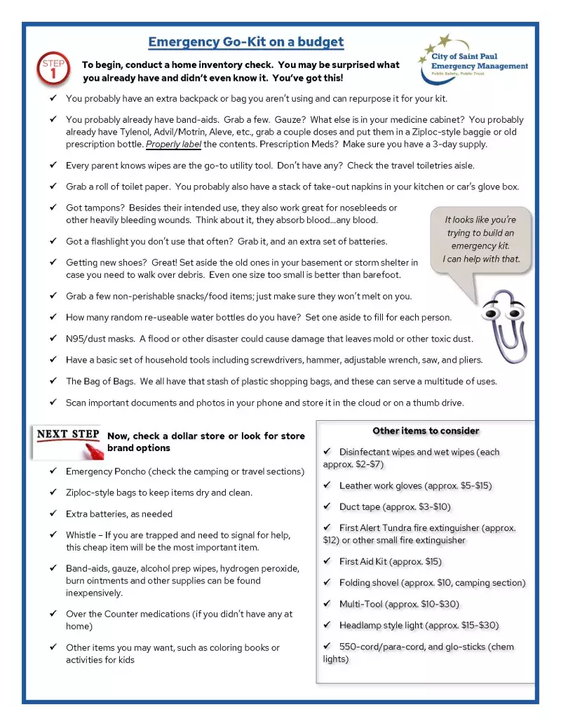
Create an Emergency Supply Kit and a Go Bag. Make sure that all members of your household know where these supplies are.
Keep a flashlight, whistle, and a pair of shoes where you go during a tornado warning, in case you need to climb out over debris, power goes out, or you need to signal for help.
Determine the best escape routes from your home. Identify at least two separate escape routes and practice using them.
Locate your gas main and other utilities. Make sure the entire household knows where they are and how to operate them.
Familiarize yourself with emergency plans at places that are a part of your everyday life, such as school, work, church, daycare, etc.
Refill medications as early as you're able to and set aside at least 3 days worth of doses for your emergency kit. Keep copies of your prescriptions electronically, either on your phone, in the cloud, or through an app like MyChart or Express Scripts.
While making your plan, consider the special needs of children, seniors, persons with disabilities, non-English speakers, and pets in your household. Don't forget about diapers, formula, pet food, and comfort items.
Make copies of all important documents and keep them off-site in a secure location. Documents to include: passports, birth certificates, social security cards, wills, deeds, driver's licenses, financial documents, insurance information, and prescriptions.
Catalog and photograph valuables. Keep these in a fireproof safe on a thumb drive or external disk drive, or stored in a cloud-based service.
Minnesota is the Land of 10,000 Lakes. If you plan to be on a boat enjoying one of these 10,000 Lakes, make sure you monitor weather conditions and have a plan to stay safe, get back to shore before the storm arrives, and what to do to be safe while you wait for the storm to pass.
The most important events during Severe Weather Awareness Week are the two annual statewide tornado drills.
In Minnesota, the 2024 statewide tornado drills are scheduled for Thursday, April 11 at 1:45 p.m. and 6:45 p.m.
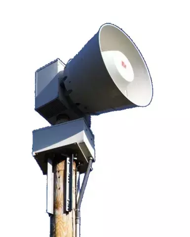
Outdoor warning sirens will sound in a simulated tornado warning.
The first drill is intended for schools, institutions, and businesses.
The evening drill is intended for second shift workers and families at home or activities.
Watches vs. Warnings
Severe Thunderstorm Watches and Warnings
A severe thunderstorm WATCH is issued by the National Weather Service when conditions are favorable for the development of severe thunderstorms in and close to the watch area. A severe thunderstorm by definition is a thunderstorm that produces one inch hail or larger in diameter and/or winds equal or exceed 58 miles an hour. The size of the watch can vary depending on the weather situation. They are usually issued for a duration of 4 to 8 hours. They are normally issued well in advance of the actual occurrence of severe weather. During the watch, people should review severe thunderstorm safety rules and be prepared to move a place of safety if threatening weather approaches. A Severe Thunderstorm Watch is issued by the Storm Prediction Center in Norman, Oklahoma
A severe thunderstorm WARNING is issued when radar indicates a severe storm has developed or a trained weather spotter reports a thunderstorm producing hail one inch or larger in diameter and/or winds equal 58 miles per hour or greater. A warning means seek shelter IMMEDIATELY.
Severe Thunderstorms can produce tornadoes with little to no warning. Lighting may be present but is not a requirement to be a severe thunderstorm. A watch may or may not be issued before the warning, and a warning typically lasts for an hour or less in duration.
Severe Thunderstorm Warnings will include where the storm was located, what towns will be affected by the severe thunderstorm, and the primary threat associated with the severe thunderstorm warning
Tornado Watches and Warnings
A Tornado WATCH is issued by the National Weather Service when conditions are favorable for the development of tornadoes in and close to the watch area. Their size can vary depending on the weather situation. They are usually issued for a duration of 4 to 8 hours. They normally are issued well in advance of the actual occurrence of severe weather. During the watch, people should review tornado safety rules and be prepared to move a place of safety if threatening weather approaches.A Tornado Watch is issued by the Storm Prediction Center (SPC) in Norman, Oklahoma.
A Tornado Warning is issued by our local National Weather Service office in Chanhassen. It will include where the tornado is located and what will be in its path. A Warning is issued when a tornado is indicated by radar or sighted by spotters; therefore, people in the affected area should seek safe shelter immediately. They can be issued without a Tornado Watch being already in effect. They are usually issued for a duration of around 30 minutes.
Outdoor Warning Sirens
Counties and cities own the sirens, and therefore decide how and when to activate them. The National Weather Service does not sound them.
Sirens are activated for
Monthly test (1st Wednesday of every month at 1 PM)
Tornado warnings
All severe thunderstorm warnings with winds in excess of 70 MPH
Sirens normally sound for about three minutes, and then go silent
If you hear the siren again, it means another threat is present
There is no such thing as an "all-clear" siren for storms
What to do when sirens are activated:
When sirens are sounded they are to alert people outside of an impending severe weather event.
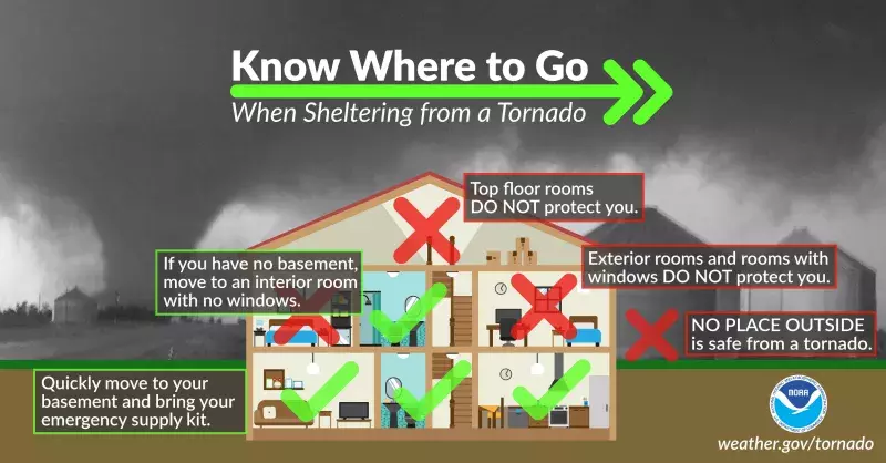
If you hear the sirens immediately stop what you are doing, go indoors and tune into your favorite local radio or tv station with a meteorologist for further details, tune into your NOAA All Hazards Weather Radio, and seek shelter immediately.
Weather Radios
A weather radio is one of the best ways to stay tuned-in to dangerous weather. These radios receive broadcasts from the National Weather Service. The broadcasts are from local weather service offices.
Broadcasts include ordinary forecasts of several kinds, including for boating, farming, traveling and outdoor recreation as well as general forecasts for the area.
The stations also broadcast all watches and warnings. Some weather radios have a feature that turn on the radio automatically when a watch or warning is broadcast. Such "tone alert" weather radios are highly recommended for places where large numbers of people could be endangered by tornadoes or flash floods. These include schools, nursing homes, shopping center security offices, hospitals, and recreation areas such as swimming pools.
NOAA All-Hazards Radio receives National Weather Service warnings, watches, forecasts and other hazard information 24 hours a day.
While primarily an auditory alert system, many off-the-shelf All-Hazards Radios are available with visual and vibrating alarm features and simple text readouts for use by deaf or hard of hearing individuals. Special adaptors can also be added to some models of All-Hazards Radios by certain vendors. These adaptors can include, colorized warning lights to indicate the level of alert, and a Liquid Crystal Display readout of specific warnings.
All Hazards Radios are programmable state/country selections that screen out alerts from other areas and can be battery-operated and portable at home, work, school, or while travelling around the country.
This video has more information on how to configure the NOAA All-Hazards Radio and with adaptors for deaf or hard of hearing individuals.
NO PLACE outside is safe when thunderstorms are in the area!
If you hear thunder, lightning is close enough to strike you.
When you hear thunder, immediately move to safe shelter: a substantial building with electricity or plumbing or an enclosed, metal-topped vehicle with windows up.
Stay in safe shelter at least 30 minutes after you hear the last sound of thunder.
Indoor Lightning Safety
Stay off corded phones, computers and other electrical equipment that put you in direct contact with electricity.
Avoid plumbing, including sinks, baths and faucets.
Stay away from windows and stay off porches.
Do not lie on concrete floors, and do not lean against concrete walls.
Last Resort Outdoor Risk Reduction Tips
If you are caught outside with no safe shelter anywhere nearby the following actions may reduce your risk:
Immediately get off elevated areas such as hills, mountain ridges or peaks
Never lie flat on the ground
Never shelter under an isolated tree
Never use a cliff or rocky overhang for shelter
Immediately get out and away from ponds, lakes and other bodies of water
Stay away from objects that conduct electricity (barbed wire fences, power lines, windmills, etc.)
Lightning Safety for the Deaf and Hard of Hearing Community
We all know that "When thunder roars, go indoors." But what if you can't hear the thunder? That's why meteorologists created a new slogan that would be more inclusive of the deaf and hard of hearing community. As a result, "See a flash, dash inside" is now used in conjunction with the original slogan above.
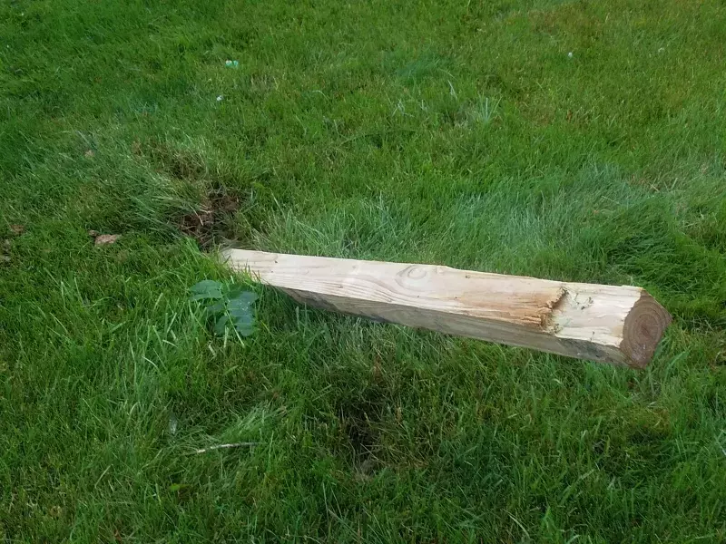
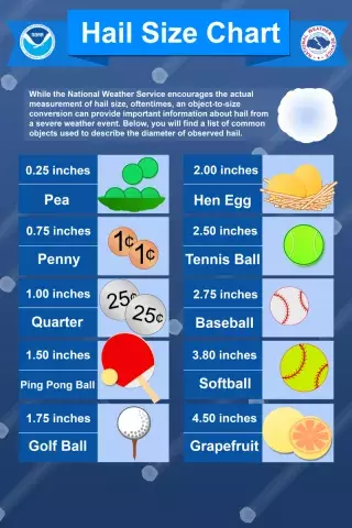
Hail is product of thunderstorms that causes nearly $1 billion in damage every year. Most hail is about pea-sized. Much of it is the size of baseballs, and it can reach grapefruit-size. Large hail stones fall faster than 100 mph and have been known to kill people.
Why do vehicles float? They float for the same reason a 97,000 ton aircraft carrier floats, buoyancy!
Where does this idea that "my heavy vehicle will keep me safe" come from? It comes from the false trust in the weight of the vehicle you are driving.
Many believe their 3,000 pound or more vehicle will remain in contact with the road surface, that it is too heavy to float. Think about that for a moment. Aircraft carriers weighing 97,000 tons float.
Vehicles, including ships, float because of buoyancy. In fact, most cars can be swept away in 18-24 inches of moving water. Trucks and SUVs do not fare much better with an additional 6-12 inches of clearance.
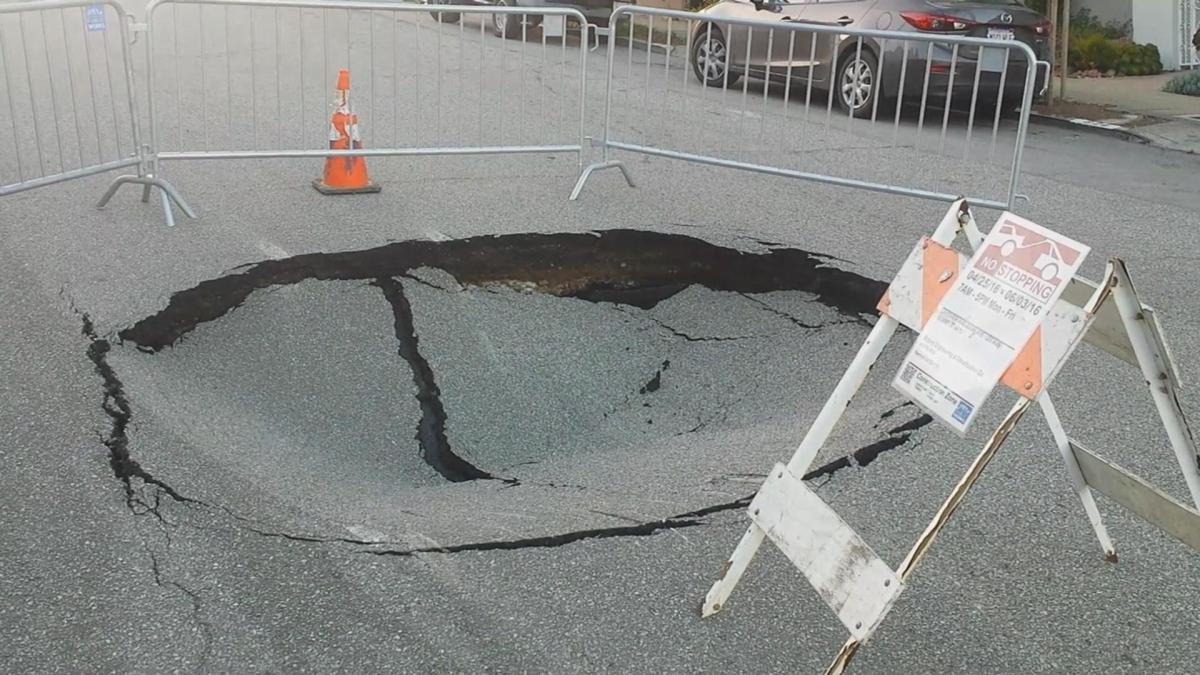
Do you know what the road looks like underneath water? Is it washed away? There are large, deep potholes across St. Paul that we are all driving carefully around. Would you drive down a road not knowing if those potholes, debris, or even worse, a sinkhole, is waiting for you? This photo is a small sinkhole in San Francisco.
When you see water and you can't see the road surface, TURN AROUND, DON'T DROWN!
Flood Insurance
FEMA's National Flood Insurance Program has information on flood insurance. Flood insurance can be purchased through your homeowner's insurance company or renter's insurance company. It typically takes 30 days to take effect, so plan ahead so you're covered when you need it.
FEMA publishes flood plain information via the National Flood Hazard Layer (NHFL). To find out more, please visit the NHFL web mapping application.
To be eligible for federal assistance under the Disaster Relief and Emergency Assistance Act, the President of the United States needs to declare the area a Federal Disaster Area. Things to be of:
Less than half of all flooding incidents result in a Presidential declared disaster.
Persons in a Federal Disaster Area are eligible for low-cost loans (not grants).
Annual flood insurance premiums are less than the interest on a Federal disaster loan.
FloodSmart.gov helps you learn about flood risk and taking steps to financially protect homes and businesses from flood damage.
Disclaimer: The information on this page is merely a summary of flood insurance information. For more information, contact your insurance agent.
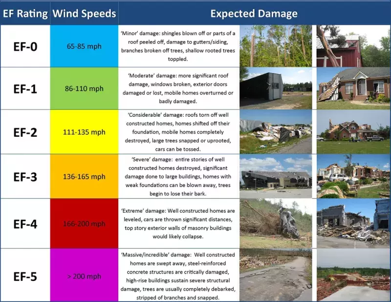
What is a Tornado?
A violently rotating column of air, usually pendant to a cumulonimbus, with circulation reaching the ground. It nearly always starts as a funnel cloud and may be accompanied by a loud roaring noise. On a local scale, it is the most destructive of all atmospheric phenomena.
According to the Department of Health (MDH), between 2000 to 2016, 54 deaths were directly attributable to extreme heat in Minnesota. On July 19, 2011, an all-time heat index record was set in Minnesota. The air temperatures was 93 degrees Fahrenheit and the heat index reached 130 degrees Fahrenheit in Moorhead.
NOAA's Watches, Warnings and Advisories for Extreme Heat
Excessive Heat Outlooks: Are issued when the potential exists for an excessive heat event in the next 3-7 days. An Outlook provides information to those who need considerable lead time to prepare for the event, such as public utility staff, emergency managers and public health officials.
Excessive Heat Watches: Are issued when conditions are favorable for an excessive heat event in the next 24 to 72 hours. A Watch is used when the risk of a heat wave has increased but its occurrence and timing is still uncertain. A Watch provides enough lead time so that those who need to prepare can do so, such as cities officials who have excessive heat event mitigation plans.
Excessive Heat Warning/Advisories: Are issued when an excessive heat event is expected in the next 36 hours. These products are issued when an excessive heat event is occurring, is imminent, or has a very high probability of occurring. The warning is used for conditions posing a threat to life. An advisory is for less serious conditions that cause significant discomfort or inconvenience and, if caution is not taken, could lead to a threat to life.
National Integrated Heat Health Information SystemHeat.gov
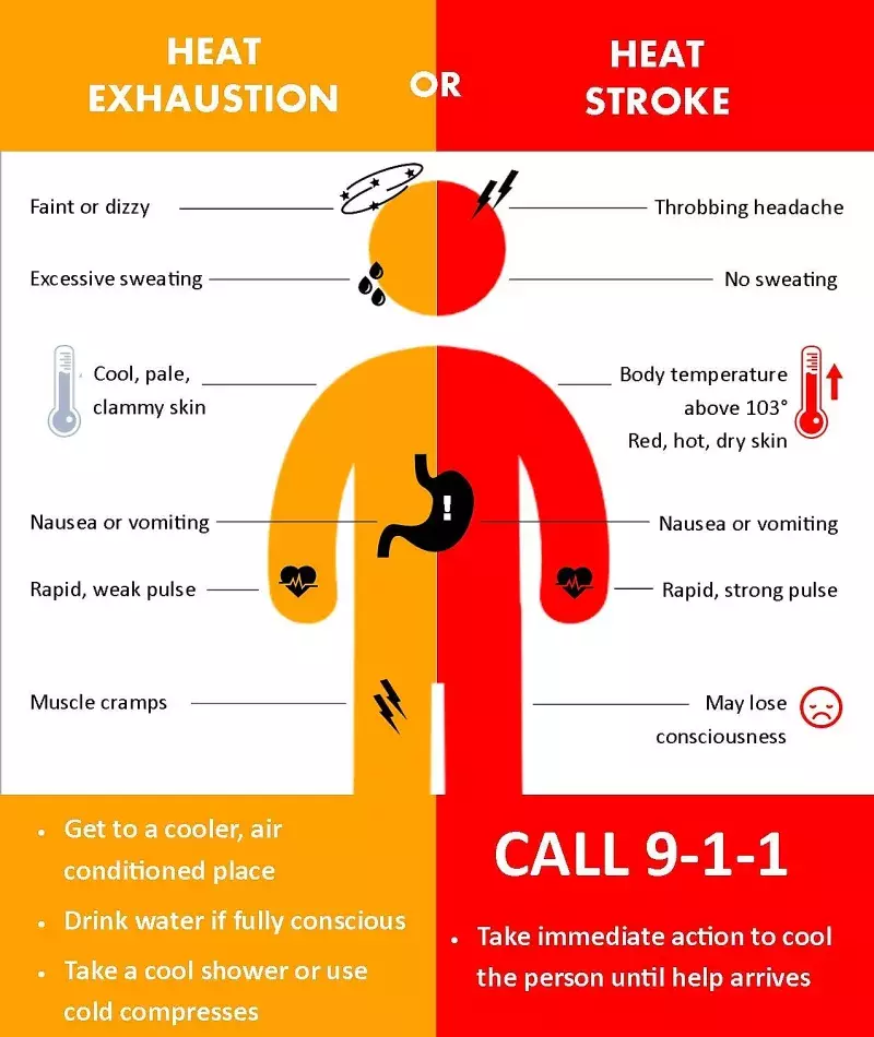
You need to drink enough water to prevent heat illness. An average person needs to drink about 3/4 of a gallon of water daily. Everyone’s needs may vary.
You can check that you are getting enough water by noting your urine color. Dark yellow may indicate you are not drinking enough.
Avoid sugary, caffeinated and alcoholic drinks.
If you are sweating a lot, combine water with snacks or a sports drink to replace the salt and minerals you lose in sweat.
Talk to your doctor about how to prepare if you have a medical condition or are taking medicines.
Heat Index
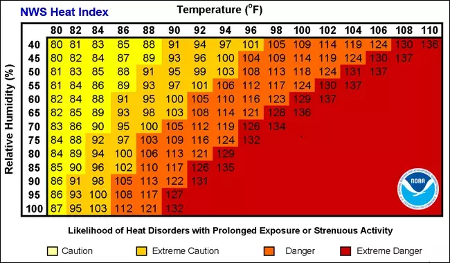
NOAA's heat alert procedures are based mainly on Heat Index Values. The Heat Index, sometimes referred to as the apparent temperature is given in degrees Fahrenheit. The Heat Index is a measure of how hot it really feels when relative humidity is factored in with the actual air temperature.
To find the Heat Index temperature, look at the heat Index chart below. As an example, if the air temperature is 96°F and the relative humidity is 65%, the heat index--how hot it feels--is 121°F. The National Weather Service will initiate alert procedures when the Heat Index is expected to exceed 105°-110°F (depending on local climate) for at least 2 consecutive days.
Interested in learning more or wanting a presentation to a group to learn more about weather and preparedness? We'd love to hear from you and see how we can help you learn how to be safe from weather hazards and other risks.
Email us and put "Public Outreach" in the subject line