Watershed Protection and Restoration

The source water from the Mississippi River is pumped through a chain of natural lakes north of Saint Paul. When the lakes are at optimum elevations, there is an available supply of 3.6 billion gallons of water. In years past, excessive nutrients in the lake reservoir system created taste and odor problems. To address these problems, the utility and partnering neighbor municipalities, began a watershed management and reservoir restoration program.

Sampling Sites

The watershed strategy established 22 sampling sites which helped identify the basic problem, nutrient enrichment, created mainly by water from the Mississippi River and Rice Creek, recirculating reservoir sediments, and runoff from local watershed rainfall.

Control Measures

Excessive nutrients, called “phosphorous loads”, increase the amount of blue-green algae which imparts taste and odor compounds. To inhibit the growth of excessive algae several controls were implemented:

  • Installation of ferric chloride feed systems
  • Installation of aerators
  • Restoring water levels to near-natural conditions in certain wetlands

The control measures targeting the Mississippi source water and the lake sediment loads have successfully reduced the phosphorus concentration from approximately 60 to 80 micrograms per liter to 20 to 40 micrograms - very near the goal of 25 micrograms. For example, restoration work on the Lambert Creek watershed area was selected by the Governor's Clean Water Initiative in 2004 as one of two metro area clean water projects. The addition of a weir, pond, and ditch in the watershed will help us reduce the phosphorus levels of water coming into Vadnais Lake.

Results

Watershed and reservoir management has reduced significantly taste and odor problems in the reservoir system and increased the effectiveness of the plant treatment process. Due to improved raw water conditions there has been a significant reduction in chemical cost. This approach allows Saint Paul Regional Water Services to provide quality, cost-effective water that meets regulations and customer expectations.
Wellhead Protection Plan

Saint Paul Regional Water Services currently uses the Mississippi River as its primary source water. As a secondary source of drinking water, SPRWS operates ten groundwater wells. These wells are available for pumping in an emergency where the surface water supply is not available. Groundwater can be pulled from the Prairie Du Chien—Jordan Aquifer at well depths ranging from 420-465 feet below the ground.

In order to protect the groundwater supply from contamination, SPRWS has developed a wellhead protection (WHP) plan. This plan includes several key components described below:

Delineation of the Wellhead Protection Area (WHPA) and Drinking Water Source Management Area (DWSMA)

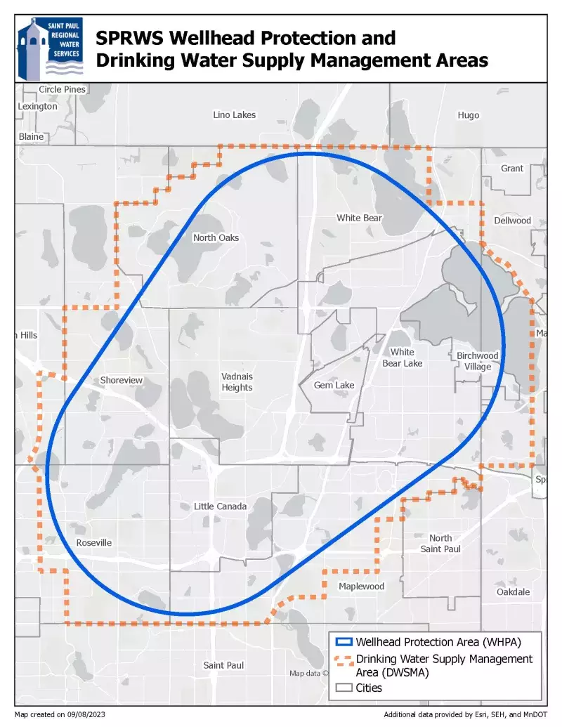
SPRWS first determined the WHPA, or where the water supplying the wells is coming from. Once the WHPA was known, the DWSMA was then determined. The DWSMA is the geographic area, including the WHPA, which is to be protected and managed by the WHP plan. Geographic landmarks such as roads and property lines were used to map the boundaries of the DWSMA to be identifiable to the general public. The DWSMA and WHPA are depicted in the figure below.

Vulnerability Assessment

Each well in the DWSMA, and the groundwater underlying the land within the DWSMA, was assessed for vulnerability. Generally, the higher the vulnerability, the greater the risk that a released contaminant would result in contaminated groundwater. The vulnerability of the wells was determined by evaluating key factors such as geology, well construction, pumping rates, and well water quality. Groundwater vulnerability throughout the DWSMA was determined by evaluating water quality and geologic sensitivity, i.e., how fast water travels vertically from the surface to the aquifer. The assigned vulnerability level of the wells and groundwater of the DWSMA informed SPRWS on how to manage potential sources of contamination as part of the WHP plan.

Inventory of Potential Sources of Contamination within DWSMA

SPRWS developed a detailed inventory of potential sources of groundwater contamination within the DWSMA. These potential sources can range from other unsealed or unused wells in the DWSMA, chemical storage areas, solid waste management sites, potential contamination sites such as brownfields, and many other possible sources. By knowing where potential sources of contamination are located, and the type of potential contamination, SPRWS is able to develop proper management strategies to protect the groundwater of the DWSMA.

Management Strategies

The implementation of the WHP plan is centered around four main management strategies: 

  • Public Education and Outreach
  • Potential Contaminant Source Management
  • Land Use Management
  • Data Collection

Emergency Response Area

SPRWS has defined an Emergency Response Area (ERA) around the ten wells in the DWSMA, depicted in the figure below. The ERA is defined as the area in which a released contaminant would take only one year of travel time in the groundwater to be possibly captured by one of the wells. Management strategies for potential contaminant sources inside the ERA are prioritized over potential sources outside the ERA.

Map of SPRWS Wellhead Protection and Drinking Water Supply Management Area

This WHP plan was approved by Minnesota Department of Health (MDH) and is in effect until 2032. SPRWS staff continuously assess the implementation of the plan.
In summary, the overall goals of the SPRWS WHP plan are to:

  • Continue and expand the public education program as needed for water usage and protection.
  • Maintain or improve SPRWS’s current drinking water quality in order to meet or exceed state and federal drinking water standards, through the management of potential sources of contamination.
  • Provide ongoing collection of data to support current and future wellhead and source water protection efforts.

Our customers can also do their part to protect the groundwater supply. One of our partner agencies, The Vadnais Lake Area Water Management Organization, has created several helpful resources that customers can reference when practicing water stewardship.

Upper Mississippi River Source Water Protection Project

The Upper Mississippi River Source Water Protection Project (UMRSWPP) was formed by the cities of St. Cloud, Minneapolis, and St. Paul, along with local units of government, to partner together for source water protection of the Upper Mississippi River.

Last Edited: September 21, 2023