Commission Background

The Saint Paul Planning Commission is a 21-member advisory body made up of resident volunteers appointed by the Mayor and approved by the City Council. The Commission reviews and makes recommendations on city planning, including comprehensive planning, zoning studies, and zoning code amendments. The Commission has four subcommittees - Zoning, Comprehensive and Neighborhood Planning, Transportation and Communications and Nominations.

The Commission’s decisions are informed by City policies and the community vision established in the 2040 Comprehensive Plan as well as specific community input. The Planning Commission strives to continually engage the community, involving the people who live, work, and recreate in Saint Paul. The 2022 Annual Report provides a summary of the Planning Commission’s major activities and accomplishments over the past year.

Download a PDF version of the 2022 Planning Commission Annual Report
Zoning Committee

The Zoning Committee hears requests for Rezonings, Conditional Use Permits (CUP), Nonconforming Use Permits (NCUP), Determinations of Similar Use (DSU), variances, occasional site plans and appeals of certain administrative decisions. Information on the administration of these zoning applications can be found in Chapter 61 of the Zoning Code.

Rezonings: amendment to a zoning district boundary or change of zoning district applied to a property; approved by City Council

Conditional Use Permits: approval of a land use subject to establish conditions; approved by Planning Commission

Nonconforming Use Permits: approval of a nonconforming land use for a specified period of time subject to established conditions; approved by Planning Commission

Determinations of Similar Use: approval of land use that may not be listed in the Zoning Code but is substantially similar to a regulated use; typically approved administratively

Variances: allowance to deviate from strict enforcement of Code standards subject to established findings; approved by the Board of Zoning Appeals or Planning Commission

Site Plan Review: review and approval of a site design; typically approved administratively but may be approved by Planning Commission

Appeals: review of an administrative of Planning Commission decision when it is alleged that an error was made; reviewed by Planning Commission or City Council


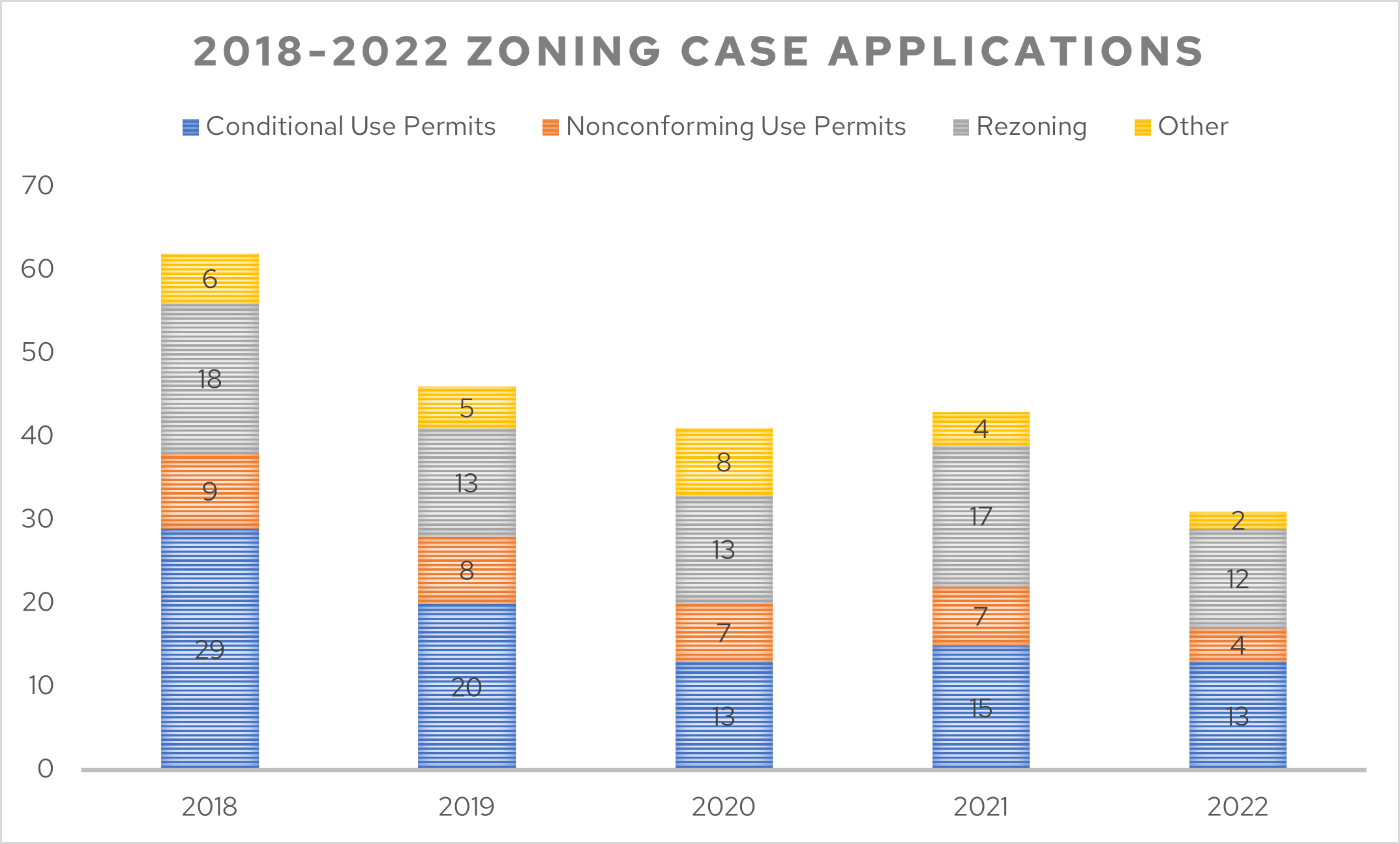
A total of 31 applications were submitted to the Zoning Committee of the Planning Commission in 2022, representing an approximately 28% decrease from last year. The number and types of cases are illustrated in annual, five-year and 10-year trends in Figures 1-4, below.

Figure 1: Zoning Case Applications, 2018 - 2022

Figure 1: Zoning Case Applications, 2018 - 2022

Figure 1 provides the number and type of zoning cases relative to one another in annual totals for the past five years. In 2022, the Planning Commission heard 31 zoning cases, the smallest number of zoning cases in the past five years. The decrease in zoning applications may be due to a variety of factors, including PED’s work to streamline the Zoning Code (i.e., fewer zoning applications are necessary when Zoning Code standards are clearer and allow more development by right), repercussions of the COVID-19 pandemic, and/or other factors.  

Conditional use permits and rezonings continue to be the most prevalent zoning applications submitted to PED. Variances are rarely heard by the Planning Commission as they are typically processed through the Department of Safety and Inspections and heard by the Board of Zoning Appeals, unless they are considered alongside another application (e.g., conditional use permit). Site plan reviews are rarely referred to, or requested by, the Planning Commission to review as they are typically reviewed administratively. The “Other” category in Figure 1 represents major master plan amendments, site plan reviews, variances and/or other administrative reviews. 


Figure 2: Zoning Case Distribution by Type, 2022

Figure 2: Zoning Case Distribution by Type, 2022

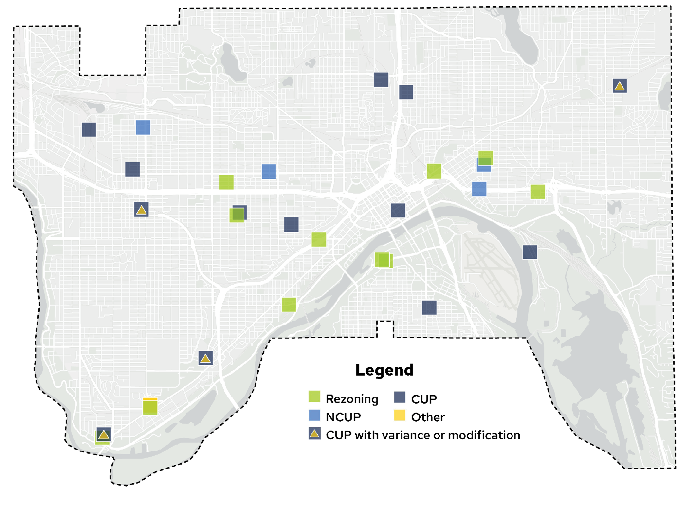
Figure 2 provides the distribution of zoning cases by type in more detail for 2022. In 2022, conditional use permits (13) and rezonings (12) were the most prevalent zoning applications submitted to PED and heard by the Planning Commission. Zoning cases were spread among many Saint Paul districts.


Figure 3: Zoning Cases by Ward, 2022

Figure 3: Zoning Cases by Ward, 2022


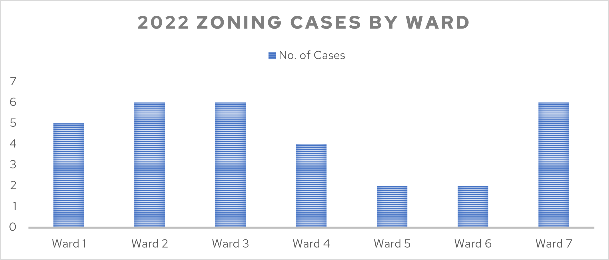
Figure 3 provides the distribution of zoning cases by ward. Wards 2, 3, and 7 were tied for most zoning cases heard by the Planning Commission in 2022 (six cases in each ward), while Wards 5 and 6 each had only two cases.


Figure 4: Appeals to City Council, 2014 – 2022

Figure 4: Appeals to City Council, 2014 – 2022

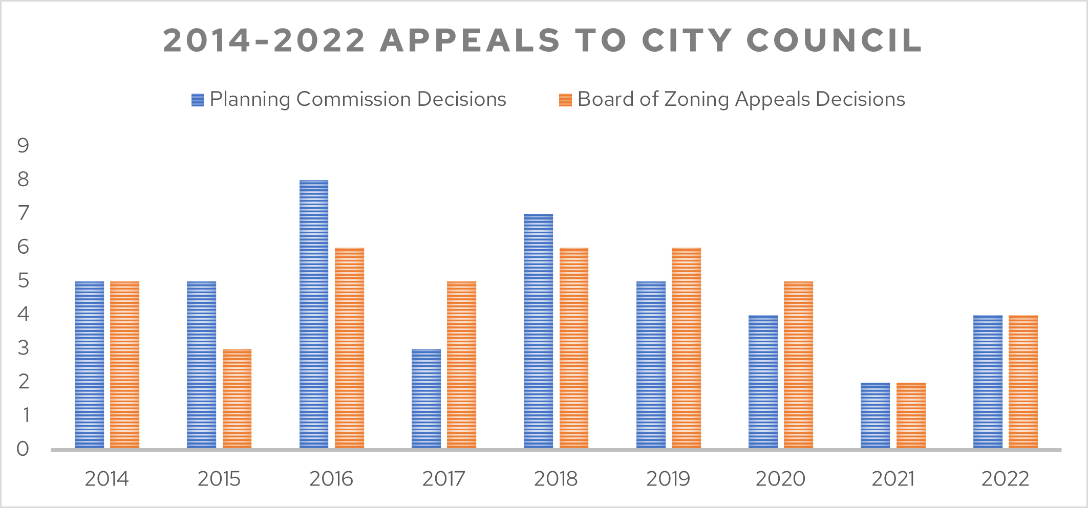
Figure 4 provides the number of Planning Commission and Board of Zoning Appeals decisions appealed to City Council from 2014 through 2022. In 2022, of the 31 zoning cases reviewed by Planning Commission, 19 of the cases were appealable to City Council; rezonings are heard by the Planning Commission but decided upon by City Council. Four of the 19 zoning cases were appealed to City Council, representing 21% of appealable decisions.

The work of the Zoning Committee is both some of the most misunderstood and most exciting work I get to do as a Saint Paul Planning Commissioner. The items that come before us offer a preview of the work our neighbors are proposing to enhance their lives and the lives of others. From innovative and culturally competent ways to house some of our most precious people – our elders and youth – to new or expanding businesses adding to the commercial/industrial mix and tax base of the Capitol city, the Zoning Committee is often one of the final steps to see plans and buildings come to life.

Commissioner Jake Reilly, Chair of the Zoning Committee

Zoning Studies and Code Text Amendments

1-4 Unit Housing Study Update

The 1-4 Unit Housing Study is examining zoning strategies to allow more neighborhood-scale housing in all areas of Saint Paul. The Phase 1 zoning code amendments focused on enabling small housing, additional accessory dwelling units, and development of small parcels. Adopted by the City Council in January 2022, these amendments went into effect on March 5, 2022.

Throughout 2022, staff continued work on Phase 2 of the study, the broader and more in-depth phase focused on developing additional zoning flexibility to support greater housing diversity in single-family, two-family, and townhouse zoning districts. The planning process is being informed by community engagement and technical analysis. Community engagement has included an online survey and virtual activities on the study’s engagement website. Technical analysis has included consultation with professionals in the small-scale development field, zoning code and parcel evaluation, and lot configuration and financial viability analysis.

Staff is nearing completion of proposed zoning code text amendments, anticipated for release in early 2023. For additional information visit Saint Paul 1-4 Unit Housing Study.


Consent Petition Requirements Elimination

The Planning Commission initiated a zoning study in February 2022 looking into consent petition requirements for some zoning application types to assess the hurdle the requirements pose to applicants and to propose amendments to the zoning code. The study carried out actions called for in the 2040 Comprehensive Plan and the Planning Commission’s policy/implementation priorities to remove unnecessary hurdles to small-scale commercial and residential development.

Consent petition requirements were waived by a mayoral executive order during the COVID-19 pandemic with no apparent problems. In June 2022, the Planning Commission recommended zoning code amendments to eliminate consent petition requirements for nonconforming and certain types of conditional use permits and the City Council adopted the amendments in August 2022.


T District Zoning Study Initiation

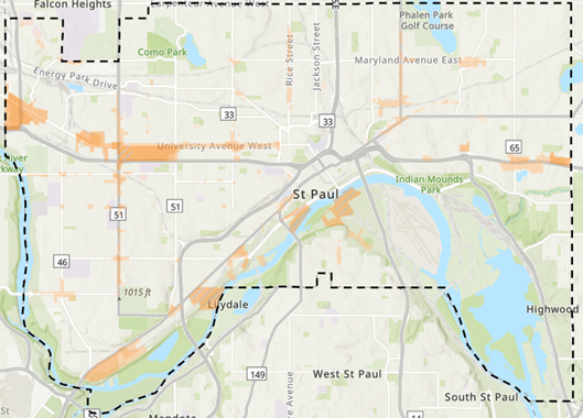
On March 4, 2022, the Planning Commission initiated the Traditional Neighborhood (T) District Zoning Study to develop zoning code text amendments to the T Districts consistent with the 2040 Comprehensive Plan. Adopted in 2004, the T Districts are intended to foster the development and growth of compact, pedestrian-oriented areas with a compatible mix of commercial and residential uses. T Districts are a prevalent zoning district designated for properties in walkable and transit-oriented environments (see Figure 5).

In April and May 2022, Planning staff distributed an email blast to district councils and business associations seeking written feedback on ideas, issues, and opportunities related to T District standards. Following this, Planning staff analyzed the T Districts overall, as well as drive-through sales and services uses and affordable housing opportunities. In 2023, Planning staff will continue working on proposed draft zoning code text amendments before conducting outreach and bringing a proposal to the Planning Commission in the spring and summer of 2023.

Figure 5: Properties Zoned Traditional Neighborhood (T1-T4)

East Grand Avenue Overlay Zoning Study Initiation

On September 16, 2022, the Planning Commission initiated a zoning study of the East Grand Avenue Overlay District. The purpose of the zoning study is to analyze the existing overlay and develop zoning code text amendments that align with the 2040 Comprehensive Plan, including policy direction for transit-supportive density, flexible building design and development standards, high quality urban design that supports pedestrian friendliness, and active first floor uses. The zoning study is also intended to align with the Summit Hill Association’s in-progress update of the Summit Hill/District 16 Neighborhood Plan, which includes policies related to land use and development across the neighborhood.

In October 2022, Planning staff began a technical analysis of zoning standards, existing development patterns, and market factors. PED, supported by Ward 2 Office and the Summit Hill Association, also retained a consultant to lead an Advisory Committee of community members that will guide the zoning study’s direction by providing advisory recommendations for consideration when Planning staff prepare zoning code text amendments. The Advisory Committee met twice in November 2022 and will continue meeting in early 2023. The zoning study is expected to be complete in summer/fall 2023.

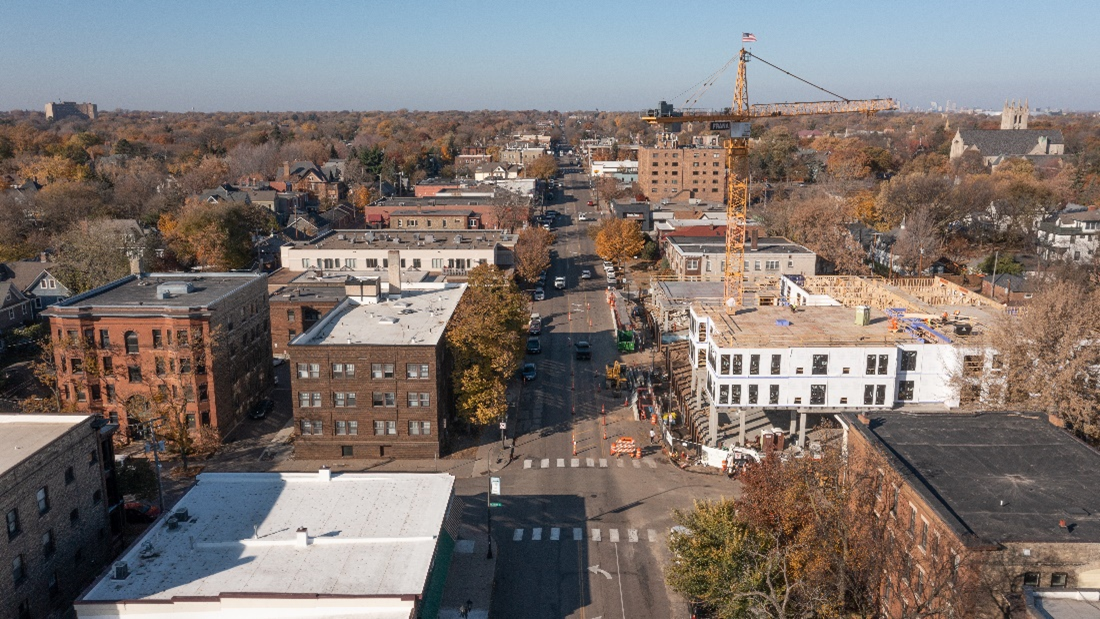
Figure 6 shows a photo taken in October 2022 of East Grand Avenue looking west. For additional information visit East Grand Avenue Overlay District Zoning Study.

Figure 6: East Grand Avenue Looking West

River Corridor & Floodplain Overlay Zoning Amendments

State Mississippi River Corridor Critical Area (MRCCA) Rules adopted in 2017 require the City to adopt new Mississippi River Corridor Critical Area (MRCCA) overlay zoning districts and regulations to comply with the new state MRCCA Rules. In 2019, the Minnesota Department of Natural Resources (DNR) developed a model Critical Area ordinance with the specific zoning code provisions, definitions, and regulations that cities within the MRCCA are required to adopt to comply with the MRCCA Rules.

On October 14, 2022, the Planning Commission released draft Zoning Code amendments based on the DNR model ordinance for public review and scheduled a public hearing on the amendments, to take place in early 2023. For additional information, visit the Mississippi River Corridor Critical Area website.

Comprehensive and Neighborhood Planning Committee

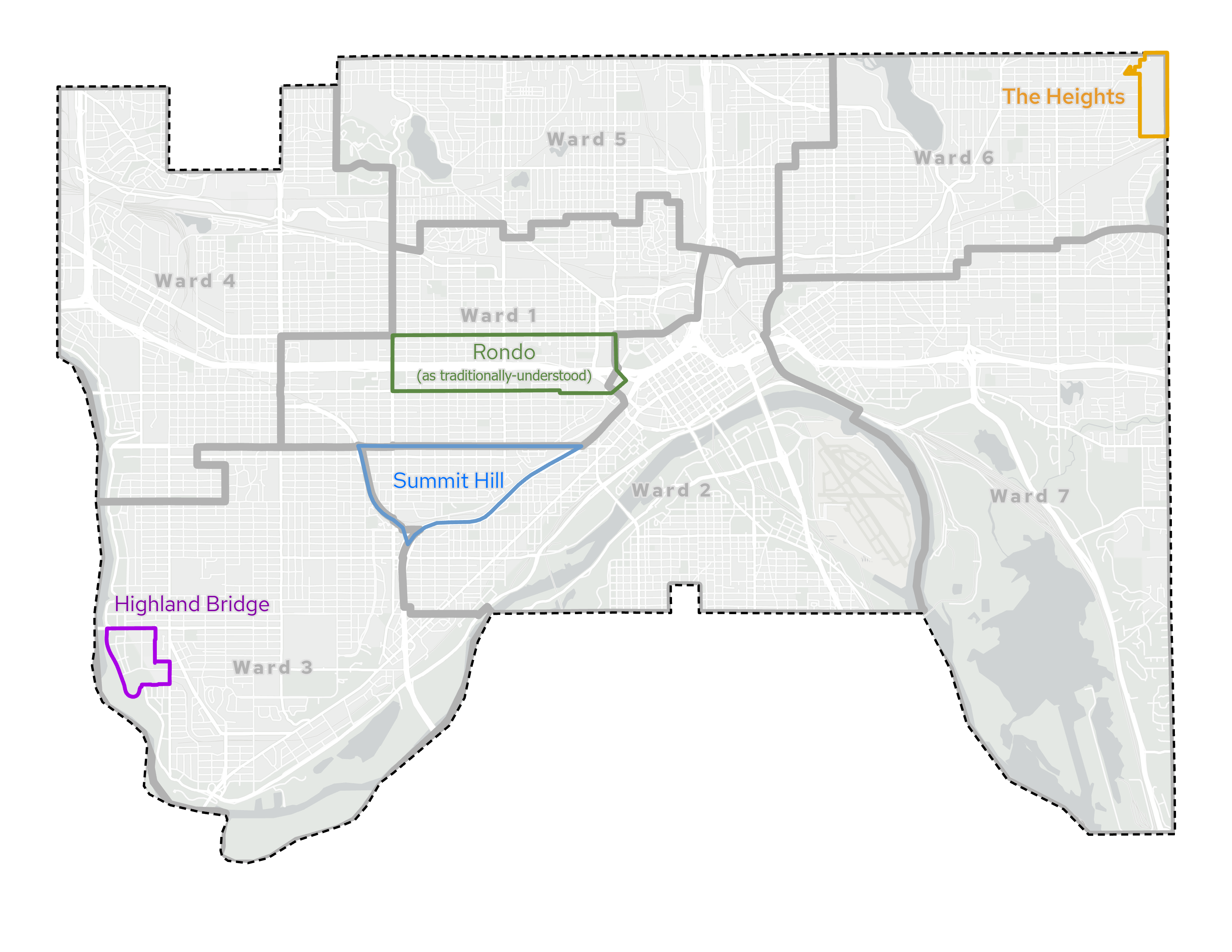
The Comprehensive and Neighborhood Planning Committee (CNPC) advises the Planning Commission on zoning studies, the adoption of zoning code text amendments, as well as comprehensive and district planning items. Planning staff conducts research and develops zoning studies that are prioritized as an implementation action of the Comprehensive Plan. District Plans are reviewed and following a public hearing and any updates, recommended to the City Council to be adopted as addenda to the Comprehensive Plan. The CNPC discusses both citywide and neighborhood projects, as described in this section. Figure 7 illustrates the locations of major CNPC projects discussed in 2022.

Figure 7: Neighborhood CNPC Projects

District Plan Guidelines Update

In 2022, Planning staff updated the District Plan Guidelines, which provide general process and content recommendations for all district councils to reference when updating a district plan. The 2022 update involved detailed reviews of district plan guidance resources dating back to 1975, including the most recent resource, District and Small Area Plan Guidelines, which was last updated in 2010.

On August 31, 2022, Planning staff provided an informational presentation to the CNPC of the Planning Commission. Members of the CNPC were given the opportunity to provide preliminary feedback on the draft District Plan Guidelines and proposed next steps. On September 22, 2022, Planning staff presented the draft District Plan Guidelines to the executive directors of district councils for initial review and feedback. Based on the CNPC’s and executive directors’ recommendations, Planning staff released the draft District Plan Guidelines for a 60-day review on October 5, 2022. Upon completion of the review period (December 9, 2022), Planning staff addressed comments provided by District Council members. Four district councils provided comments, which were generally positive and included clarifications on the roles of steering committees and Planning Commission task forces, intent and content of work plans, and maps, data, and general support that PED staff may provide to district councils.

Planning staff presented the revised District Plan Guidelines to the Planning Commission on January 6, 2023. Planning Commission expressed support for the update with minor comments and feedback. Planning staff expects to publish the District Plan Guidelines on the City website in early 2023.


Summit Hill District Plan Update

Over the past two years, the Summit Hill Association and neighborhood volunteers, with support from City staff, have been working on updating the Summit Hill/District 16 Neighborhood Plan, which will provide a 10-year vision to guide neighborhood growth, investment, and development. Following a consultant’s market analysis report and extensive community engagement that included several public meetings, an online survey, listening sessions, workshops, and other events and activities, the Summit Hill Association Neighborhood Plan Committee incorporated community input into draft Neighborhood Plan chapters that were released for public comment in 2022. The draft will be presented to the Summit Hill Association Board before formal submission to the City for staff review in early 2023, which will eventually lead to a final Neighborhood Plan draft that will go through the Planning Commission and City Council approval processes.


Anti-displacement and Community Wealth Building Project

This year, the Commission adopted a resolution supporting the establishment of a committee of community developers to advise the City and a consultant for the citywide Anti-displacement and Community Wealth-building Technical Study. This technical study will identify, explore and analyze the feasibility and likely effectiveness of a variety of potential strategies toward minimizing displacement risks for low-and-moderate income people and businesses, while simultaneously encouraging new housing production and business investment. Consistent with a related Commission’s 2021 resolution, the project includes an inclusionary zoning assessment and a study of financial and market feasibility of inclusionary housing policies given Saint Paul’s market context. The project kicked off in 2022, with preliminary community engagement, a landscape analysis, and a Community Advisory Committee convening. Additional engagement, technical reports and staff recommendations are to come in 2023.

For additional information, visit the Saint Paul Anti-Displacement Plan.


The Rondo African American Cultural Enterprise District

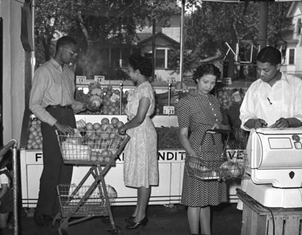
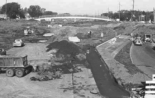
Between 1956 and 1968, the construction of I-94 demolished the once vibrant Rondo corridor, razing approximately 700 homes and 300 businesses and leaving the community damaged by the destruction of the social, cultural, and economic center of the African American Community in Saint Paul. See Figure 8 for an example of one of the businesses destroyed by the interstate. The direct impact of the construction of I-94 (see Figure 9), resulted in the Rondo community experiencing a 48% decline in home ownership, a 61% decline in population, and combined loss of $157 million dollars of unrealized home equity value, from demolished homes in the I-94 corridor. For more information on the history of the Rondo neighborhood, visit Reconnect Rondo.

Figure 8: Interior of the Crediafawn Co-op Store, 678 Rondo Avenue, 1950 (Credit: Reconnect Rondo)

Figure 7: Interior of the Crediafawn Co-op Store, 678 Rondo Avenue, 1950

Reconnect Rondo is leading an effort to reignite a vibrant African American Cultural Enterprise District anchored by a community land bridge. The intent of these efforts is to help restore the past prosperity of the Rondo neighborhood and reduce the disparities that still exist today, as a direct result of the construction of I-94. Reconnect Rondo is supported by the Rondo Roundtable, a group of advisors representing various local businesses and organizations. Planning Commission aims to continue to support and elevate the work being completed by Reconnect Rondo and the Rondo Roundtable.

The Rondo Land Bridge project aims to create up to five blocks of newly developable land above and along the I-94 right-of-way, which would be leveraged to create new opportunities to build intergenerational wealth for Rondo elders, descendants, and current Rondo residents. Through the establishment of a Community Enterprise Trust, the Rondo community will have a mechanism to directly own and invest in future development on the land bridge and surrounding area, and through the establishment of a Community Reinvestment Fund, a portion of the revenue generated from the development would be used to fund housing and economic development in the broader cultural enterprise district.

Having secured $6.2 million dollars from the Minnesota Legislature, Reconnect Rondo has begun work on numerous studies that are being supported by its staff and City staff. Staff is anticipating that the project team will ask the Planning Commission to initiate a small area planning study in the first quarter of 2023.

Figure 9: I-94 Construction Causing Destruction of the Rondo Neighborhood (Credit: Reconnect Rondo)

Figure 8: I-94 Construction Causing Destruction of the Rondo Neighborhood

Rondo Area Property Research in Support of the Inheritance Fund

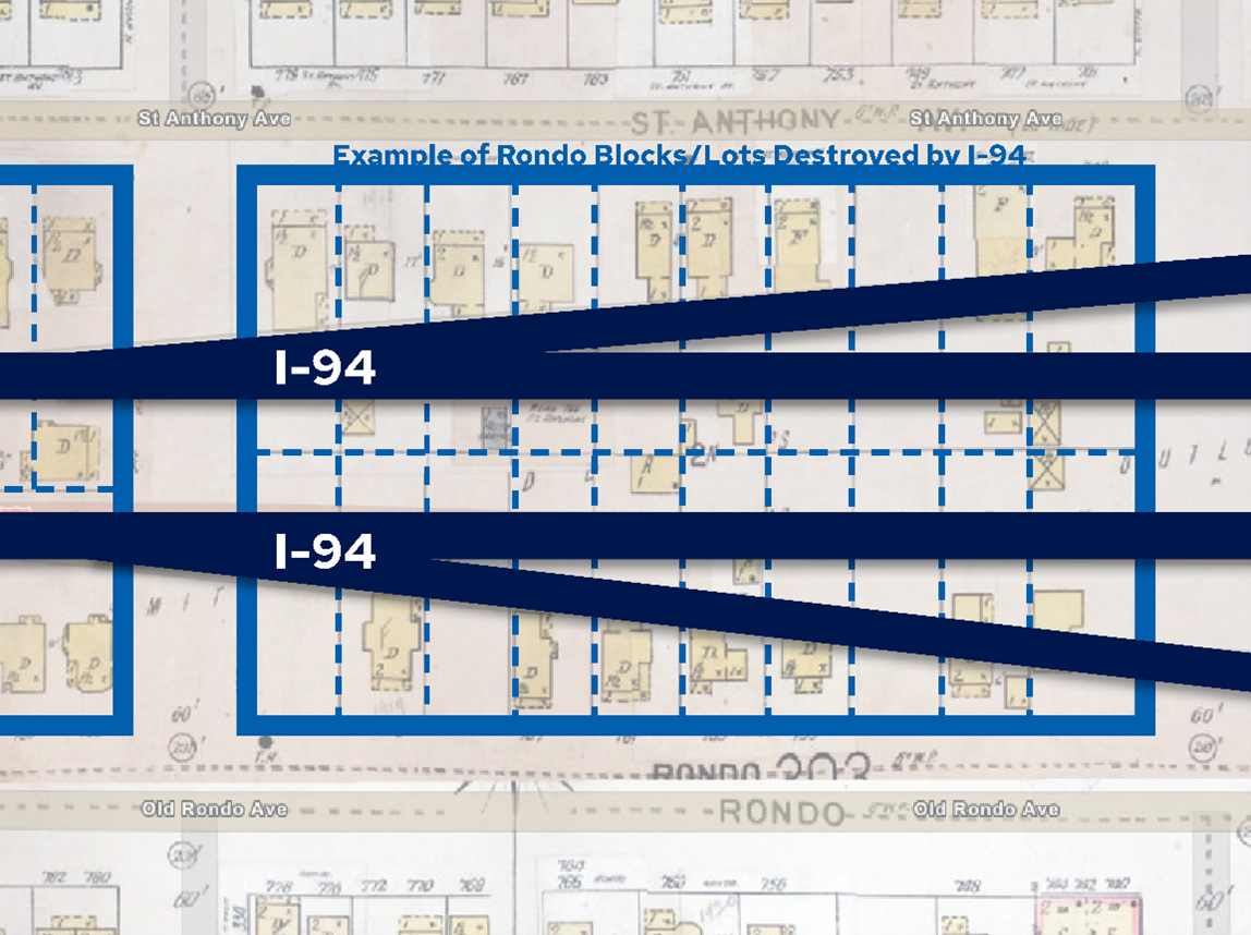
This year, City Heritage Preservation and PED Research staff collaborated on researching and mapping historic data about properties that were taken in the Rondo community during planning and construction of I-94 (see Figure 10), as well as during other disruptive and displacing urban renewal events such as: the Western Area Addition (1958), the Cathedral Hill Redevelopment Area (1963) and the Central Village Addition (1976) that impacted thousands of residents and businesses. This work will help support Mayor Carter's Inheritance Fund initiative which will assist current and former Rondo residents (and their descendants) who lost properties with the construction of the Interstate with loans for down payments to purchase homes, or to rehabilitate existing housing in Saint Paul.

Figure 10: Example of Rondo Blocks/Lots Destroyed by I-94

Figure 9: Example of Rondo Blocks/Lots Destroyed by I-94

Large Site Redevelopment

Master planning and implementation for large redevelopment sites continued to progress in 2022. This section summarizes updates on The Heights and the Highland Bridge redevelopment.


The Heights

The Planning Commission and City Council approved a rezoning, master plan, and associated amendments for the former Hillcrest Golf Course (now known as “The Heights”). The 112-acre development will provide a new 5-acre park and around 1,000 living-wage, low-barrier-to-entry jobs and 1,000 housing units at full build out.

The Saint Paul Port Authority (SPPA) has begun design work and real estate promotion of the project.  Plats, grading permits, remediation, site plan permits, and initial vertical construction are expected in 2023.


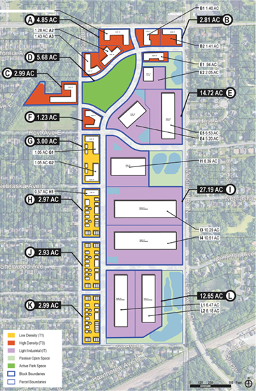
Figure 11 illustrates the location, size, and land use classification for parcels available for housing and light industrial development opportunities. SPPA will select one master housing developer and light industrial users to build on these individual parcels ranging from two to 20 acres. All development partners will need to work within the parameters of the City of Saint Paul’s Hillcrest Master Plan, which was approved by City Council in June 2022.

Figure 11: Potential Development Scenario for The Heights (Credit: Saint Paul Port Authority)
Figure 10: Potential Development Scenario for The Heights

Highland Bridge

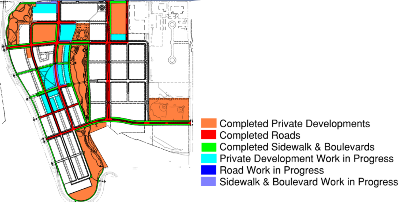
The Ford Site Zoning and Public Realm Master Plan was adopted by the City Council in September 2017. In June 2018, Ford Land announced Ryan Companies as the Master Developer for the site. Construction of infrastructure and vertical projects began in 2019 and is anticipated to continue for approximately a decade. Figure 12 illustrates completed and in-progress projects as of late 2022.

Figure 12: Highland Bridge Projects Completed and In Progress (Credit: Ryan Companies)
Figure 11: Highland Bridge Projects Completed and In Progress

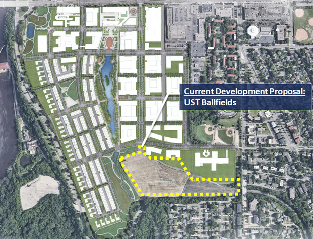
As anticipated, there have been numerous amendments to the Master Plan as build out has occurred and market and site realities have materialized. In 2022, the University of Saint Thomas (UST) and Ryan Companies proposed an athletic complex on an approximately 23-acre site owned partially by Canadian Pacific Railway in the southeast corner of the Master Plan area (see Figure 13). Several Master Plan amendments were proposed as part of the development; however, the applicant withdrew all but minor amendment applications in the summer of 2022 to redesign the footprint and features of the athletic complex.

Figure 13: Highland Bridge Site Plan Showing UST Proposed Project Site (Credit: Ryan Companies)
Figure 12: Highland Bridge Site Plan Showing UST Proposed Project Site

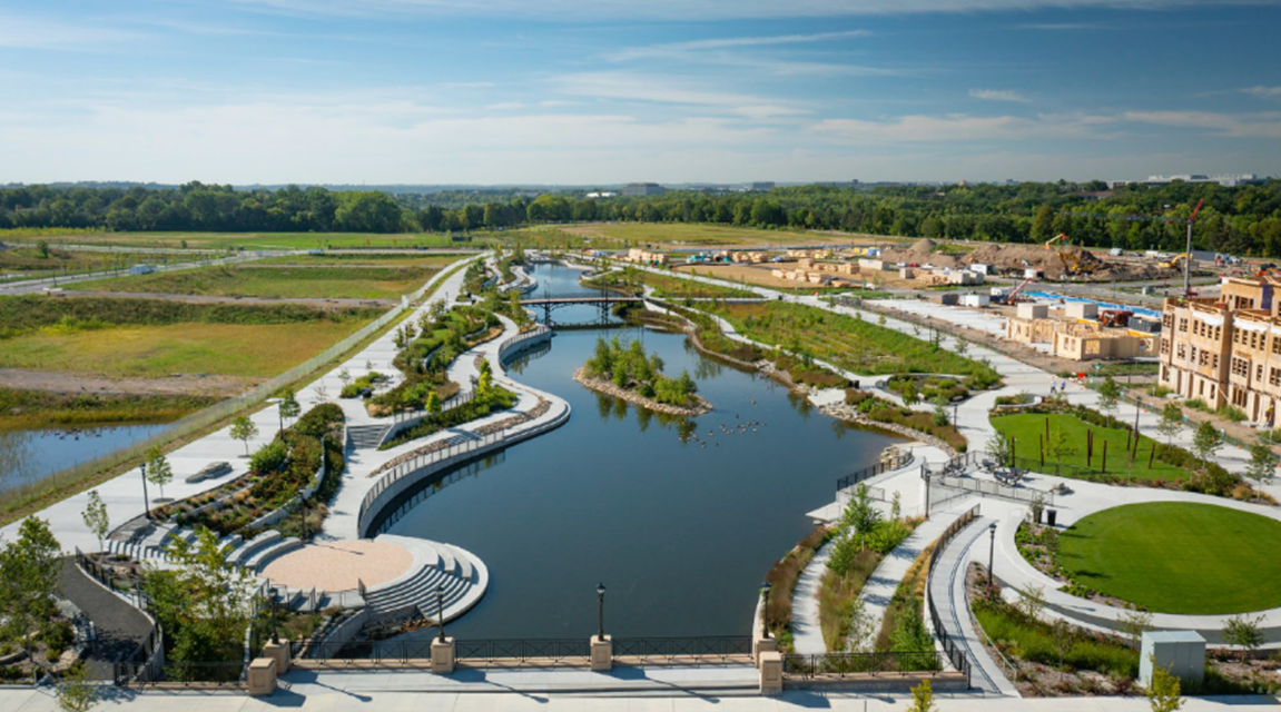
On August 9, 2022, much of the Highland Bridge public infrastructure opened to the public, including the central stormwater feature (see Figure 14).  On September 29, 2022, the Lunds & Byerlys on the site opened, facilitated by an expanded Commercial Development District found to be consistent with the Comprehensive Plan by the Planning Commission.

Figure 14: Highland Bridge Central Stormwater Feature (Credit: Drone Brothers)
Figure 13: Highland Bridge Central Stormwater Feature

Transportation Committee

The Transportation Committee advises the Planning Commission, City Council, and staff on transportation planning and certain project decisions. The Committee is authorized to implement policies of the Transportation Chapter of the Comprehensive Plan and guide related zoning amendments and studies. Additionally, the Committee reviews certain Public Works projects and can advise on site plans and concept plans to ensure inclusion of multi-modal transportation system considerations.

Chairing the Transportation Committee has given me the unique opportunity to work closely with both citizen members and fellow commissioners. They bring a wealth of technical expertise and common sense to inform the plans and design of a wide range of project impacting the entire community. Whether you walk, bike, roll, or drive, the committee is working to ensure we have a safe and accessible transportation system that balances the needs of all of us.

Commissioner Jeff Risberg, Chair of the Transportation Committee


Saint Paul Bike Plan Update

The Bike Plan, originally adopted in 2015, is being updated with two main objectives: to include more separated bike lanes and paths, and to identify where and how to prioritize resources to expand the bike network. Preliminary community engagement occurred in 2022. A draft plan will be released in 2023 for public comment and eventual adoption.


Rice Street Vision and Reconstruction Project

Throughout 2022 and into 2023, Ramsey County and the City have continued progress on a community-driven vision for Rice Street between Pennsylvania Avenue and Wheelock Parkway. The purpose of the Rice Street project is to leverage the planned roadway reconstruction to:

  • Promote economic growth and community investment while maintaining and providing business opportunities;
  • Create an inviting environment;
  • Enhance pedestrian and bicyclist safety;
  • Maintain and augment transit service; and
  • Continue to increase vehicle safety.

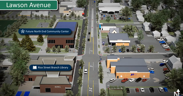
In 2022, the visioning portion of the Rice Street project finalized a roadway layout concept (see Figure 15). The selected layout improves multi-modal accessibility and safety through a 4-to-3 lane conversion, an enhanced sidewalk on the east side, the introduction of a shared use path on the west side, and crossing improvements throughout the corridor.

Figure 15: Rice Street Vision Study Concept, North End (Credit: Bolton and Menk and Ramsey County)
Figure 14: Rice Street Vision Study Concept, North End

The project is now in the design phase, which will further evaluate location-specific mobility and community design improvements. Reconstruction of Rice Street is anticipated to begin in 2024 and will be implemented over multiple phases.

Supporting the design process is a Livability Implementation Framework, which seeks to promote the broad coordination of corridor livability improvements, supportive of, and catalyzed by, the roadway project. Staff from Saint Paul, Ramsey County, and adjacent stakeholders continue to be engaged with the design and livability aspects of the reconstruction project.

For more information, visit Ramsey County Rice Street Project.


EV Spot Network & Evie Carshare

After more than four years of planning, engagement, and collaboration, the Evie Spot Network and Evie Carshare officially launched in 2022. This project represents the first of its kind in the Northern Hemisphere as a collaborative effort between the Cities of Saint Paul and Minneapolis, utility provider Xcel Energy, and nonprofit carshare provider HOURCAR. The EV Spot Network is a series of 70 renewably powered curbside charging hubs within Saint Paul and Minneapolis that offer public access to the new Evie Carshare service and EV charging stations. Evie Carshare has over 150 all-electric, one-way carshare vehicles. These vehicles are free-floating within a 35-square mile home area across Saint Paul and Minneapolis.


Riverview Corridor Streetcar Update

The Ramsey County-led Riverview Corridor Project made substantial progress in 2022, particularly related to station area planning. The Riverview Station Area Planning Task Force is co-chaired by a Planning Commission member and transitioned from Commissioner Grill to Commissioner Underwood’s leadership in 2022. Drafts of plans for the eight station areas outside of downtown are expected to be released in 2023.


Gold Line Rapid Transit Update

Metro Transit’s Gold Line BRT project began construction in 2022 and the line is expected to open in 2025.  It will provide all day frequent service between Woodbury and downtown Saint Paul.


Purple Line Bus Rapid Transit Update

Metro Transit’s Purple Line BRT project progressed to 30% design in 2022. Metro Transit is recruiting community members to participate in station area planning working groups in 2023. Construction is scheduled to begin in 2024 with an opening date in late 2026. It will provide all day frequent service between Union Depot and northeast suburbs (endpoint is to be determined).

Communications and Nominations Committee

The Communications and Nominations Committee aims to increase public knowledge and educate the community about the work of the Planning Commission. Committee members assist City staff with recruitment while reviewing and making recommendations of applications from members of the community to fill Planning Commission vacancies.

Committee members also review and approve the Planning Commission Annual Report. The Committee provides more inclusive community engagement efforts by supporting planning staff in developing and delivering planning-related training in the community.

Younger people on these boards really have an impact on decisions. I feel like motivated young people should always be part of the decision-making spaces--we will be impacted by these decisions most.

Youth Transportation Committee member Dowon Hall

Mayor Carter has expressed a goal of having youth commissioners serve on every City of Saint Paul board and commission. To this end, in 2022, the Transportation Committee appointed two youth members to participate in the decision-making process. The Communications and Nominations Committee strives to ensure that younger voices are represented on Planning Commission committees. The Committee and City staff plans on prioritizing additional youth recruitment at the end of 2023, going into 2024.

Planning Commissioners Serving in 2022

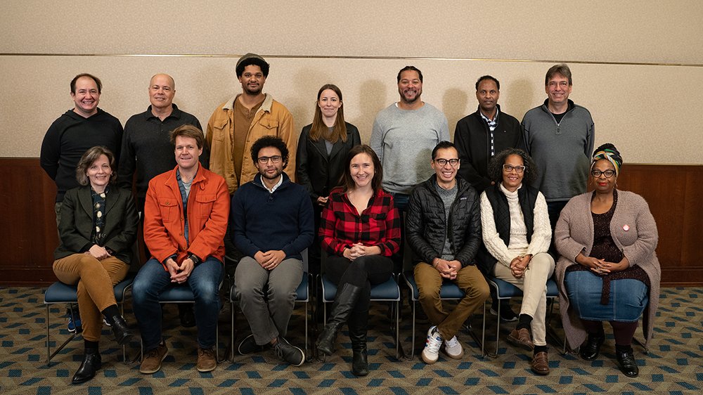
Planning staff thanks all 2022 Planning Commissioners (see Figure 16) for their commitment to guiding the future of Saint Paul. We recognize the effort and expertise it takes to lead development decisions in a thoughtful and equitable way, and we commend the Planning Commission and its committees for the work accomplished this year. We would like to recognize Wendy Underwood, in particular, for her nine years of service on the Planning Commission, including service on the Transportation Committee and acting as Chair of the Communications and Nominations Committee. Thank you, Commissioner Underwood and the rest of the Planning Commission for another meaningful year. 

I love the City of Saint Paul.  I choose to live here for its character, its opportunities, and its commitment to community. That's why I've enjoyed my time as a Saint Paul Planning Commissioner and Chair of the Nominations and Communications Committee. It's one more way for me to support and give back to my home, to talk about all of the important work and decisions before the City, and to encourage other Saint Paul residents to join in the conversations. Whenever I run into someone whom I helped appoint to the Saint Paul Planning Commission, I feel a glimmer of pride, knowing I was a part of one more person's involvement with the City and its future. I will be forever grateful for this opportunity!

Commissioner Wendy Underwood, outgoing chair of the Communications and Nominations Committee and retiring Planning Commissioner

  • Luis Rangel Morales, Chair
  • Kristine Grill, First Vice Chair
  • Wendy Underwood, Second Vice Chair
  • Nieeta Presley, Secretary
  • Nathaniel Hood
  • Troy Hackney
  • Richard Holst
  • Libby Kantner
  • Ismail J. Khadar
  • Garrison McMurtrey
  • Deborah Mitchell
  • Stephen Moore
  • Mauricio J. Ochoa Rosales
  • Jacob Reilly
  • Jeffrey Risberg
  • Elizabeth Starling
  • Omar Syed
  • Simon Taghioff
  • Seanne Thomas

Figure 16: 2022 Planning Commissioners

Planning Commission Group Photo - Saint Paul 2022

Last Edited: February 8, 2023