The Saint Paul Planning Commission is a 21-member advisory body made up of resident volunteers appointed by the Mayor and approved by the City Council. The Commission reviews and makes recommendations on city planning issues, including comprehensive planning and zoning studies and amendments. The Commission has four subcommittees; Zoning, Comprehensive and Neighborhood Planning, Transportation, and Nominations and Communications. The Commission’s decisions are informed by the City policies and community vision as set out in the 2040 Comprehensive Plan, Saint Paul for All, and input from the public. The Planning Commission strives to continually engage the community, involving the people who live, work, do business, and play in Saint Paul.

The 2021 Annual Report provides a summary of the Planning Commission’s zoning cases, major activities, and accomplishments over the past year. Due to the ongoing COVID-19 pandemic, Planning Commission meetings and Subcommittee meetings were held virtually via Microsoft Teams. The public was able to attend the meetings virtually online or by phone and provide feedback for public hearings via live testimony or in writing.
Zoning Committee

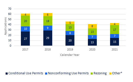
The Zoning Committee hears requests for Rezonings, Conditional Use Permits (CUP), Nonconforming Use Permits (NCUP), Determinations of Similar Use (DSU), variances, occasional site plans, and appeals of certain administrative decisions. A total of 43 applications were submitted to the Zoning Committee of the Planning Commission in 2021, up slightly from last year, a change of 5 percent.

The number and types of cases submitted are illustrated in annual, five, and ten-year trends. Figure 1 provides the number and type of cases relative to one another in annual totals for the past 5 years. CUPs continue to be the application type most frequently submitted with 21 per year on average over the five-year period. Rezonings are the next most frequent case type submitted with 16 cases submitted, on average.


Figure 1. Zoning Case Applications, City of Saint Paul, 2017-2021

Figure 1. Zoning Case Applications, City of Saint Paul, 2017-2021

*Other = DSU, stand along variance, site plan review, or appeals of administrative decisions.


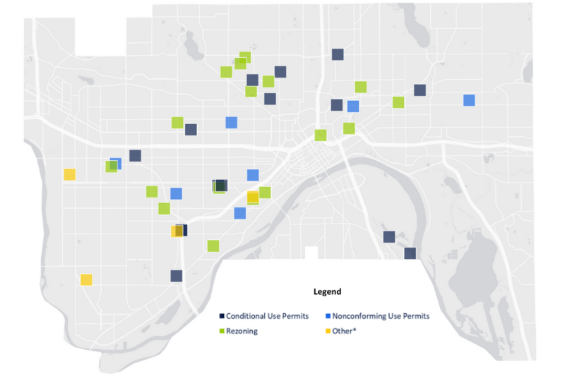
Figure 2. Zoning Case Distribution by Type, City of Saint Paul, 2021

Figure 2 is a citywide zoning case point distribution map by type, for calendar year 2021.

Zoning Case Distribution by Type

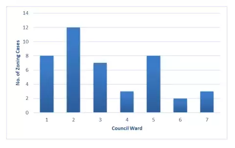
Figure 3. Zoning Cases by Ward, City of Saint Paul, 2021

The third figure shows the distribution of zoning cases by Ward. Ward 2 had the greatest number of cases submitted (12) in 2021. Wards 1 and 5 had the next highest number, each having 8 cases this past year.

Figure 3.  Zoning Cases by Ward, City of Saint Paul, 2021

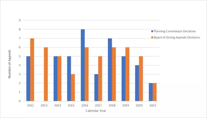
Figure 4. Appeals to City Council, Saint Paul, 2012-2021

The fourth figure provides the number of Planning Commission and Board of Zoning Appeals decisions appealed to City Council from 2012 through 2021. Over the past decade, annual fluctuations in the number of appeals to the City Council of Planning Commission decisions ranged from zero cases in 2013 to eight in 2016. This past year, of the 43 cases reviewed by the Planning Commission, 26 decisions could have been appealed; rezonings are reviewed by the Planning Commission but decided upon by the City Council. Two cases (8%) of 26 Planning Commission decisions were appealed to the City Council in 2021.

Figure 4.  Appeals to City Council, Saint Paul, 2012-2021

Highlighted Zoning Cases

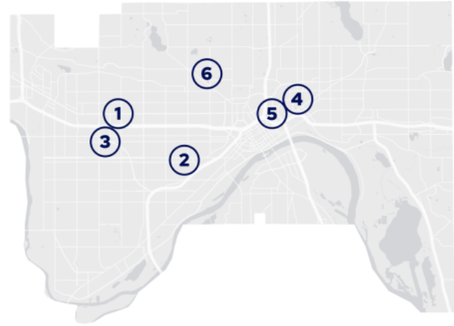
Highlighted Zoning Cases from 2021 Annual Report placed on a map

Notable zoning cases are presented to highlight multifamily and mixed-use development plans submitted in 2021.

The selected cases include market rate apartments and those with a mix of affordability while illustrating the sometimes controversial nature of items that go before the Zoning Committee.


Lexington Station Apartment Site Plan

Case #1

Number 1 in circle

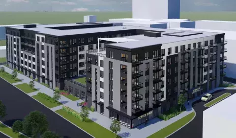
In December 2020, Alatus Development LLC submitted a site plan application for the vacant property at 411-417 Lexington Parkway for Lexington Station Apartments, a proposed six-story mixed-use building with 288 apartment units, 3,000 square feet of ground floor commercial space, and 254 parking spaces. After staff recommended approval with conditions of the site plan application, finding the site plan in compliance with the 11 Zoning Code requirements related to site plans, the Zoning Committee held a public hearing and voted to recommend approval of the site plan with conditions.

After much discussion, the Planning Commission then voted 8-7 to deny approval of the site plan application finding it inconsistent with the 2040 Comprehensive Plan’s core values of equity, affordability, and resiliency, and inconsistent with two Traditional Neighborhood zoning district design standards. Alatus Development LLC appealed the Planning Commission’s decision to the City Council, who narrowly denied the appeal 4-3 in April 2021. Mayor Melvin Carter vetoed the Council’s decision, in part saying that while the City does need additional affordable housing, it also needs additional housing units for all income levels which this project would help provide.

This case illustrated the complex discussions about and varied solutions to the current housing crisis in Saint Paul.


Case #2

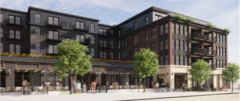
695 Grand Avenue Rendering
Zoning Case #2

In June 2021, the development team and property owner, St. Albans LLC, of 695 Grand Avenue submitted a rezoning, Conditional Use Permit (CUP), and variance applications following three months of Summit Hill neighborhood engagement on a proposed mixed-use project that included 80 market-rate apartments, four ground-floor commercial spaces, and structured parking.

The proposed project measured five-stories, exceeding the strict limits established by the East Grand Avenue Overlay District (EGAOD) for building footprint, building size and height (a maximum of 36’/3 stories).

Similar to what the Summit Hill Association recommended, staff recommended approval of the rezoning to T3 and denial of the rezoning out of the EGAOD. The Zoning Committee and full Planning Commission voted 16-2 to recommend the T3 rezoning to City Council who then narrowly approved this rezoning.

The Planning Commission reviewed the Conditional Use Permit and variance request as a separate case. After staff recommended approval and a public hearing was held, the Zoning Committee and Planning Commission approved the CUP and variances. A group of concerned neighbors appealed these approval decisions by arguing that the project was not consistent with the Comprehensive Plan and that the need for variances was based solely on economic considerations.

The City Council denied the appeal 5-2 in September. These zoning cases sparked significant community interest – including over 200 letters, a 400-signature petition in opposition, and dozens of speakers at the public hearings prompting intense discussion about the project’s compatibility with the neighborhood, role of the EGAOD and potential conflicts with Comprehensive Plan goals, and the property owner’s practical difficulty with complying with the EGAOD requirements.


Case #3

Number 3 in circle

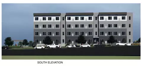
The first new housing to be built east of Snelling after properties were rezoned as part of the West Marshall Avenue Zoning Study in 2018 may be at 1509 Marshall Avenue. The Planning Commission approved a CUP for additional height for a multi-family development of 60 units affordable at 80% of the area median income (AMI).

1509 Marshall Avenue Elevation

Case #4

Number 4 in circle

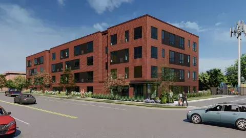
A rezoning case for a property owned by the Housing and Redevelopment Authority was submitted in May for 520 Payne Avenue. The requested change in zoning from I1 to T2 allows for the proposed 62-unit multi-family development with eighty percent of units affordable at 60% of the AMI. The developer is Johnny Opara of J.O. Companies.

520 Payne Avenue

Case #5

Number 5 in circle

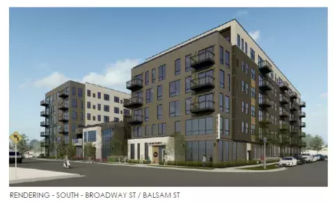
A rezoning case for a development proposal with a potentially significant impact to the affordable multifamily housing stock was submitted in March of 2021. L & N Black Properties LLC requested a rezoning of 554 Broadway Avenue from I1 to B5 to allow for a 133 unit multi-family building with the expressed intent that all the units be affordable at 30% to 80% of the AMI.

554 Broadway Avenue Rendering

Case #6

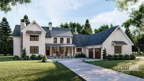
420 Front Street - Project GLOW
Number 6 in circle

A CUP application for another type of housing solution was submitted by Allan Kingdom, a new BIPOC developer with local roots. Project GLOW is a 3,200 square foot residence for young men of color with mental health and substance addiction challenges. Supportive housing is conditionally permitted in the RM2 medium density multifamily zoning district. Staff recommended approval of the CUP based on Comprehensive Plan housing policy to accommodate a wide variety of housing types to support residents at all ages of life and ability, increase housing choice for residents of all income levels, foster the preservation of deeply affordable housing, including supportive housing for people experiencing homelessness. The Planning Commission concurred with staff recommendation for approval as there is a severe shortage of housing opportunities available for homeless youth and this at-risk population. The CUP was unanimously approved for supportive housing for up to 17 individuals.

Comprehensive and Neighborhood Planning Committee

The Comprehensive and Neighborhood Planning Committee (CNPC) advise on zoning studies, the adoption of Zoning Code text amendments, as well as some occasional district planning items. Planning staff conduct research and develop zoning studies that are prioritized as an implementation action of the Comprehensive Plan or district/area plans incorporated within as adopted addenda.


District and Small Area Planning work

Planning District 12 Plan update: The Planning Commission recommended the new Saint Anthony Park Community 10-year Plan as an update to the previous plan adopted in 2008 and amended in 2013. Neighborhood plans are generally updated every ten years and need to be consistent with the Comprehensive Plan. The St. Anthony Park Community Council (SAPCC) undertook an extensive survey and engagement process in 2017, including online surveys (400 respondents participated), in-person surveys to ensure diversity of input, and a supplemental business survey that fall. The plan was organized around the following questions:

  • What will we do to ensure equitable access for all in housing, jobs, food, and movement from place to place?
  • What will we do to respond to climate change, as a neighborhood within a city?
  • What will we do to support the shift to a creative, more diverse economy?

Notably, the plan included chapters for Equity, Climate Change, and Economic and Business Development, all of which are above and beyond those typically included in a neighborhood plan; these topics represent issues most important to the neighborhood. Planning Commission held a public hearing on March 5, 2021 and recommended the plan to City Council on April 16, 2021.

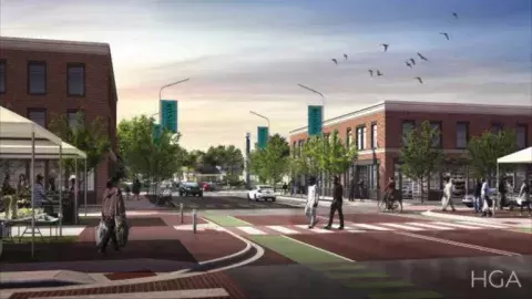
Reconnect Rondo

Reconnect Rondo Rendering courtesy of HGA

Reconnect Rondo (RCR) is a community organization creating Minnesota’s first African American cultural enterprise district connected by a community land bridge. The African American cultural enterprise district is designed to repair, restore and revitalize Rondo.

This was a significant year for RCR and the Rondo land bridge project in terms of reigniting community and technical conversations and securing resources to further define and begin implementing the vision. In the spring, the State legislature approved a $6 million appropriation to MNDOT to support Reconnect Rondo. These funds will be used for master planning and predevelopment activities. The City also worked with RCR to secure a $150,000 Metropolitan Council Livable Communities pre-development grant to study anti-displacement and right to return policies specific to the area surrounding the project.

In June, RCR and the Urban Land Institute (ULI) convened technical experts and community members to develop further details for its 4P model (Public, Private, Philanthropy and People), and that work is ongoing. RCR presented an update on their progress to the Planning Commission and pledged to continue engaging them going forward. For more information, please visit RCR’s website: ReConnect Rondo.


Zoning Studies and Code Text Amendments

Definition of Family Study

After a recommendation in 2020 from the Planning Commission to raise the zoning maximum for occupants of a dwelling unit, the City Council passed Ordinance 21-4 unanimously in March of 2021. The ordinance raised the number of permitted occupants in a home, removed consideration of relatedness from the zoning code, and changed the zoning code term from Family to the more accurate Household. Specifically targeted for study by the 2040 Comprehensive Plan Housing Policy 17 and City Council Resolution 18-1204, this text amendment contributes to more fair and equitable access to housing for Saint Paul’s diverse array of residents and household styles.

Parking Regulations

In 2018, the Planning Commission initiated a zoning study to update provisions in the zoning code pertaining to minimum parking requirements. The purpose of the study was to implement policies in the Comprehensive Plan such as reducing vehicle miles traveled in Saint Paul by 40% by 2040, and policies in the Climate Action and Resiliency Plan such as achieving carbon neutrality by 2050. In response to this policy direction, staff developed two packages of amendments for the Planning Commission to consider.

One package of amendments would eliminate minimum parking requirements from the zoning code, while the alternative package of amendments would reduce minimum parking requirements by introducing additional targeted exemptions and administrative reductions. In addition to reducing or eliminating minimum parking requirements, both options would amend travel demand management (TDM) provisions, introduce a TDM supplemental guide, provide bike parking standards that are specific to land uses, require the cost of parking to be unbundled from the cost of housing, and streamline processes and standards.

On March 19, 2021, the Planning Commission released the study for public review. After the study was released, staff gave two webinars nd offered presentations for any district council, business association, or neighborhood group that requested a presentation.

On April 30th the Planning Commission held a public hearing where 237 written comments were received. Roughly 70% of the comments were in favor of the option to eliminate minimum parking requirements. On June 25th the full Planning Commission voted to recommend that the City Council and Mayor adopt the option to fully eliminate minimum parking requirements. The City Council and Mayor followed the recommendation of the Planning Commission, and the proposed amendments were signed into law on September 1, 2021.

For additional information visit the Parking Study page.

Ford Open Space Amendments

The Planning Commission and City Council considered and adopted amendments to lot coverage requirements in the Ford Site Zoning and Public Realm Master Plan that brought implementation of the regulations more in line with the original intent of the Master Plan by clarifying what could be used for a project to receive a lot coverage bonus and more directly incentivizing green roofs.

Homeless Services

In November 2020, an emergency ordinance was approved by the Mayor and City Council to permit services to unsheltered homeless individuals in a former fire station at 296 7th Street West (“Freedom House”) on a temporary basis, tied to the COVID-19 pandemic. An emergency ordinance was needed, in part, because the principal use of daytime services to people experiencing homelessness is not defined in the Zoning Code. On recommendation from the Planning Commission, the City Council adopted the Homeless Services zoning code amendments in November 2021 to create a definition and standards for a “homeless services facility” (sometimes also called a “day shelter”) and allow the use (past the pandemic) in many locations across the city, subject to certain standards. Such facilities are part of the City’s coordinated response to the housing crisis and unsheltered populations.

Religious Accessory Uses

Upon receiving a great deal of comment via an October public hearing for the Religious Accessory Uses Zoning Study, the Planning Commission recommended zoning code amendments that would make it clearer and easier for religious institutions to incorporate common complementary activities on their campuses, including services to people experiencing homelessness. The City Council acted on the recommendation in January in order to meet the February 1, 2022 deadline that was established by a 2019 legal agreement tied to Listening House in Dayton’s Bluff.

1-4 Unit Housing Study

In April 2021, the Planning Commission initiated the 1-4 Unit Housing Study to evaluate the potential for allowing more neighborhood-scale housing across the city in response to current housing needs and future demands and direction from City Council Resolution 18-1204 and 2040 Comprehensive Plan policy. The study is structured in two phases, with Phase 1 focused on enabling physically smaller homes and removing barriers to the construction of accessory dwelling units (ADUs). The Phase 1 text amendments were adopted by the City Council on January 19, 2022.

Phase 2 of the study, which involves a broader scope of policy questions and review of the Zoning Code to support greater housing diversity such as duplexes, triplexes, and fourplexes in more places as well as facilitating more types of single-family homes, is in the technical analysis and public engagement stage in late 2021, and this will continue in 2022.

Industrial Zoning Study

The Planning Commission initiated a study to evaluate the compatibility of allowed uses in industrial districts with the district intent as well as their consistency with recently adopted policy in the 2040 Comprehensive Plan.

Inclusionary Zoning Study

Following spirited deliberations and a denial by the Planning Commission of the Lexington Station Apartments site plan in the spring, the Planning Commission discussed and adopted a resolution recommending that the City re-initiate a study about Inclusionary Zoning, emphasizing the importance of adequate resources and staffing for it. In September, the PED staff released a Request for Proposals for a technical consultant to study a variety of anti-displacement and community wealth-building tools, including inclusionary zoning.

Large Site Redevelopment

Master planning and implementation for large redevelopment sites has continued to progress in 2021. Highland Bridge, Hillcrest, Snelling-Midway and the former Sears property are significant redevelopment sites within the City. Each is at different stages of the redevelopment process - community engagement, master plan development and adoption, environmental review, platting, site plan reviews, and construction of both infrastructure and vertical development.


Highland Bridge

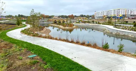
Highland Bridge development under construction

The Highland Bridge / Ford site has seen dramatic changes in 2021. Many of the primary rights-of-way have been constructed. Also nearing completion is the 13-acre spine of public space consisting of a central plaza, large stormwater feature, and one of four city parks on the site. The gateway park in the northeast corner of the site is also nearly complete. Vertical development has also begun, with a Presbyterian Homes senior living project under construction on Block 6, a 230-unit mixed-use project with grocery at ground level, and the first of the site’s townhouses, which will serve as model units for the developer. Additional development is pending in 2022. For more information visit Highland Bridge (Ford) Site pages online.


Snelling-Midway Alternative Urban Areawide Review (AUAR)

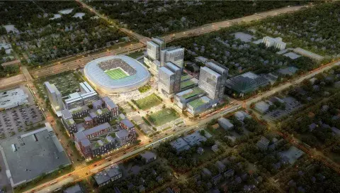
Snelling Midway Site Rendering

Allianz Field, home of the Minnesota United Football Club, began construction in 2016 and included significant public investments in infrastructure. Under state law, the Alternative Urban Areawide Review (AUAR)—an environmental review required in Minnesota prior to construction due to the size of the stadium—is required to be updated after 5 years if all proposed construction in the area examined has not been completed. City staff worked with the owner of the land surrounding the stadium, site of the former Midway Shopping Center, and consultants to work on a draft update to the AUAR in 2021. The shopping center building north and east of Allianz Field and the Big Top liquor store building along University Avenue, both within the AUAR area, were damaged by fire in 2020 and demolished in 2021.


Sears Redevelopment

While located in the City of Saint Paul, the zoning and redevelopment of the former Sears site at is governed by the Capitol Area Architectural and Planning Board (CAAPB), a State of Minnesota Board. In March 2021, CAAPB voted to begin the community engagement process for the redevelopment of the Sears site in anticipation of a formal submittal of a master plan to the CAAPB for review. Since that time, CAAPB staff and the development team, supported by City staff, have begun engagement and the process of meeting with City departments, District Councils, and various other stakeholders. The design process laid out by CAAPB staff, agreed to by the development team, calls for four iterations of concept plans to be developed with public and City staff input informing each. Additionally, the project team has developed a survey which is available now online on the CAAPB’s Sears Master Plan project website. While the concept plan is undergoing changes in late 2021/early 2022, imagery from an initial development scenario for the site from early 2021 can be found on the CAAPB’s project website.


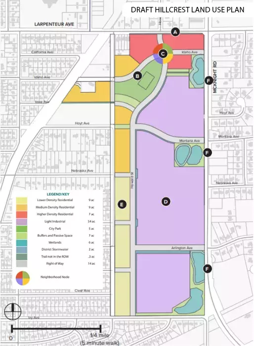
Draft Hillcrest Master Plan

Hillcrest Redevelopment Land Use Plan with Legend

The draft of the Hillcrest Master Plan's four initial site approaches reviewed in 2020 were progressed to two finalist scenarios for broad community feedback in spring 2021. Substantial infrastructure and other technical analysis were conducted to inform the planning, and the transportation analysis was reviewed by the Transportation Committee. A full draft master plan document was built around a single final scenario which received feedback from the Community Advisory Committee in late 2021, in preparation for the Planning Commission review process in 2022. The Hillcrest development is expected to bring about 1,000 jobs and 1,000 housing units to fruition on this site.

Key Elements of the Draft Hillcrest Land Use Plan

(A) Higher density housing located at the primary corner of McKnight Road and Larpenteur, near the location of the designated Neighborhood Node.

(B) A City park owned and operated by the City located at the Neighborhood Node. Park to be designed for active recreation, gathering and events that facilitate community building.

(C) A Neighborhood Node is located on the north side of the site where a variety of compact and relatively dense uses come together in a walkable environment.

(D) Large flexible light industrial blocks along McKnight Road.

(E) Lower and medium density housing along the seam with the existing neighborhood to the west.

(F) Wetlands along McKnight Road are incorporated into the districts stormwater system and are leveraged as a public asset as passive open space.

Transportation Committee

The Transportation Committee advises the Planning Commission, City Council, and staff on transportation planning and certain project decisions. The Committee is authorized to implement policies of the Transportation Chapter of the Comprehensive Plan and guide related zoning amendments/studies. Additionally, the Committee reviews certain Public Works projects and can advise on site plans and concept plans to ensure inclusion of multi-modal transportation system considerations.

Transit Projects

During 2021, the Transportation Committee participated in projects with partner agencies Ramsey County and Metro Transit to ensure transportation options evaluated are consistent with citywide plans and policies. The Committee discussed Bus Rapid Transit (BRT) projects at various stages of environmental investigation, community engagement, plan development, and implementation timelines as follows:

  • Purple Line: The Purple Line BRT project (formerly Rush Line) completed 25% plans and Environmental Analysis in 2021 as it readied for a project leadership transition from Ramsey County to the Metropolitan Council for the next phase of planning in 2022, which includes project development and advanced station area planning.

  • Gold Line: Informed in part by the City’s Gold Line Station Area Plans and Transportation Committee input in previous years, Metro Transit’s Gold Line BRT project progressed from 60% plans to 90% and 100% plans in 2021. Construction will begin in 2022 with an opening date of 2025.

  • Metro B Line: The Metro B Line is a planned Bus Rapid Transit (BRT) line that will provide faster and more reliable transit service in the Route 21 corridor along Lake Street and Marshall and Selby avenues. In 2021, after the Transportation Committee provided feedback in the spring, the Metropolitan Council established the final corridor plan, including specific stop locations.

  • G Line and H Line: In April 2021, the Metropolitan Council established the next set of arterial BRT lines for development in the region, including the G Line (Rice/Robert) and H Line (Como/Maryland) in Saint Paul. In 2020, the Transportation Committee had recommended the Rice/Robert and Como/Maryland corridors be the region’s top priorities, and that equity and serving new neighborhoods be prioritized scoring criteria.

Capital City Bikeway

Saint Paul’s transportation planning efforts are designed to make the city more accessible, safe and attractive for people who walk, drive, use transit or bike. In addition to the BRT projects, the Transportation Committee continued to advise the City about the Capital City Bikeway (CCB), a planned network of bicycle facilities throughout downtown Saint Paul.

The CCB continued to advance forward this past year after beginning construction in 2017, which continued into 2020. With input from the community and technical study, Public Works made the decision to select Wabasha and 10th Street as the west and north corridors of the CCB, in line with what the Transportation Committee recommended in April.

Rice Street Corridor

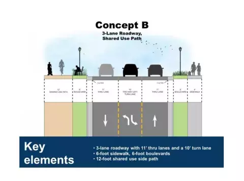
Rice Street Corridor Concept B

The Committee also participated in transportation corridor planning studies with Ramsey County. The Rice Street and Riverview corridors provide different mode choices and roadway contexts, both of which are under technical study and executing community engagement processes for public and private stakeholder input.

The design of roadway and intersection options for the Rice Street is not only a multi-modal transportation and traffic engineering study to enhance mobility and safety, but a community driven vision for revitalization. Goals include economic growth, community investment, maintenance of business opportunity, and the creation of an inviting environment with enhanced pedestrian, bicyclist and vehicular safety. The Rice Street corridor will have maintained and augmented transit service as design aspects are being coordinated with future G line infrastructure requirements.

Representatives from the Rice Street Visioning Study met with the Transportation Committee in August, sharing project background, public engagement activities, and three draft roadway concepts. The committee identified Concept B as its preference, which has since been advanced as a draft recommended concept. The alternative design consists of two thru lanes and one central left turn lane, a 12’ shared use bicycle and pedestrian path, 6’ boulevards, 6’ sidewalks, and some parking options. Additional information and the ability to comment on the project is available by visiting the Rice Street Visioning Study project website.

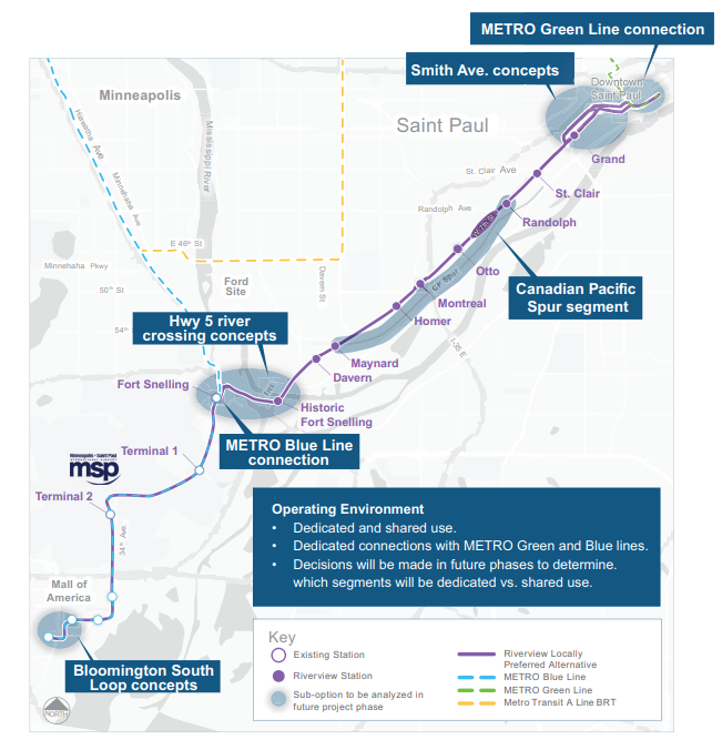
Riverview Locally Preferred Alternative Route

Advanced Station Area Planning (ASAP) for the Riverview Corridor modern streetcar began in Spring 2021. Led by Ramsey County, in partnership with the City of Saint Paul, the process will identify ways to promote safe and direct station access, as well as transit-oriented development (TOD) within a walking distance of future transit stations.

The Station Area Planning Task Force, co-chaired by a Planning Commissioner, will guide the development of these plans over the next two years. To learn more and subscribe to updates on Riverview, visit the Riverview Corridor website.

Riverview Corridor Locally Preferred Alternative Route

2021 Planning Commissioners

  • Anne DeJoy
  • Kristine Grill, First Vice Chair
  • Nathaniel Hood
  • Richard Holst
  • Libby Kantner
  • Garrison McMurtrey
  • Deborah Mitchell
  • Stephen Moore
  • Nieeta Presley, Secretary
  • Luis Rangel Morales, Chair
  • Jacob Reilly
  • Jeffrey Risberg
  • Omar Syed
  • Simon Taghioff
  • Seanne Thomas
  • Wendy Underwood, Second Vice Chair
  • Zhijun Yang

To learn more about current Planning Commissioners or find out about when applications are accepted each year visit the Meet the Commissioners page.

Download a PDF version of the report

Last Edited: January 26, 2023