Overview 

Planning staff completed major updates to the Traditional Neighborhood Districts in 2025. City Council then directed staff to apply those zoning districts across the city. Amending the Zoning Map to add more T Districts will address the need for comprehensive, consistent economic and land use flexibility on properties located along some of Saint Paul’s primary commercial and mixed-use transit corridors. Easing and diversifying the development of new housing, creation of new businesses, and adaptive reuse opportunities along transit corridors will contribute to the City’s goals for vibrant, walkable neighborhoods and increased access to rapid transit.  Six major corridors in Saint Paul will receive T District zoning in 2026. 
Background  

Traditional Neighborhood (T) Districts are used throughout Saint Paul, especially along transit corridors and at major intersections, and for individual projects. T Districts:  

  • Encourage compact, mixed-use development  
  • Improve walkability at nodes and along corridors  
  • Permit dense development to support transit ridership  
  • Allow for more flexible uses for existing buildings than typical business zoning 


T Districts were first adopted in 2004 to create more opportunities for the kind of mixed-use that was common as the city originally developed, which is the reason for the name “Traditional.” They have since become a popular choice for rezonings due to their flexibility and pedestrian-focused design standards. They were amended in 2011, and further amended in 2025 to provide additional incentives for affordable housing, improve design, and bring greater predictability to the development process. Upon adopting those amendments, the City Council initiated the next phase of work to evaluate expanded use of T Districts along transit corridors within the city 

Study Area  

Map amendments will take place along corridors in Saint Paul that have recently received or will soon receive BRT. Active BRT routes in Saint Paul today include the A Line, B Line, and Gold Line, much of which has already been studied for rezoning. BRT routes benefit from higher-quality, more frequent transit service and infrastructure upgrades. Adding more T District zoning along the next set of BRT corridors will link improved transit with economic development and new housing. Together, these factors contribute to neighborhood vitality, walkability, and opportunity. These are key goals in the 2040 Comprehensive Plan.

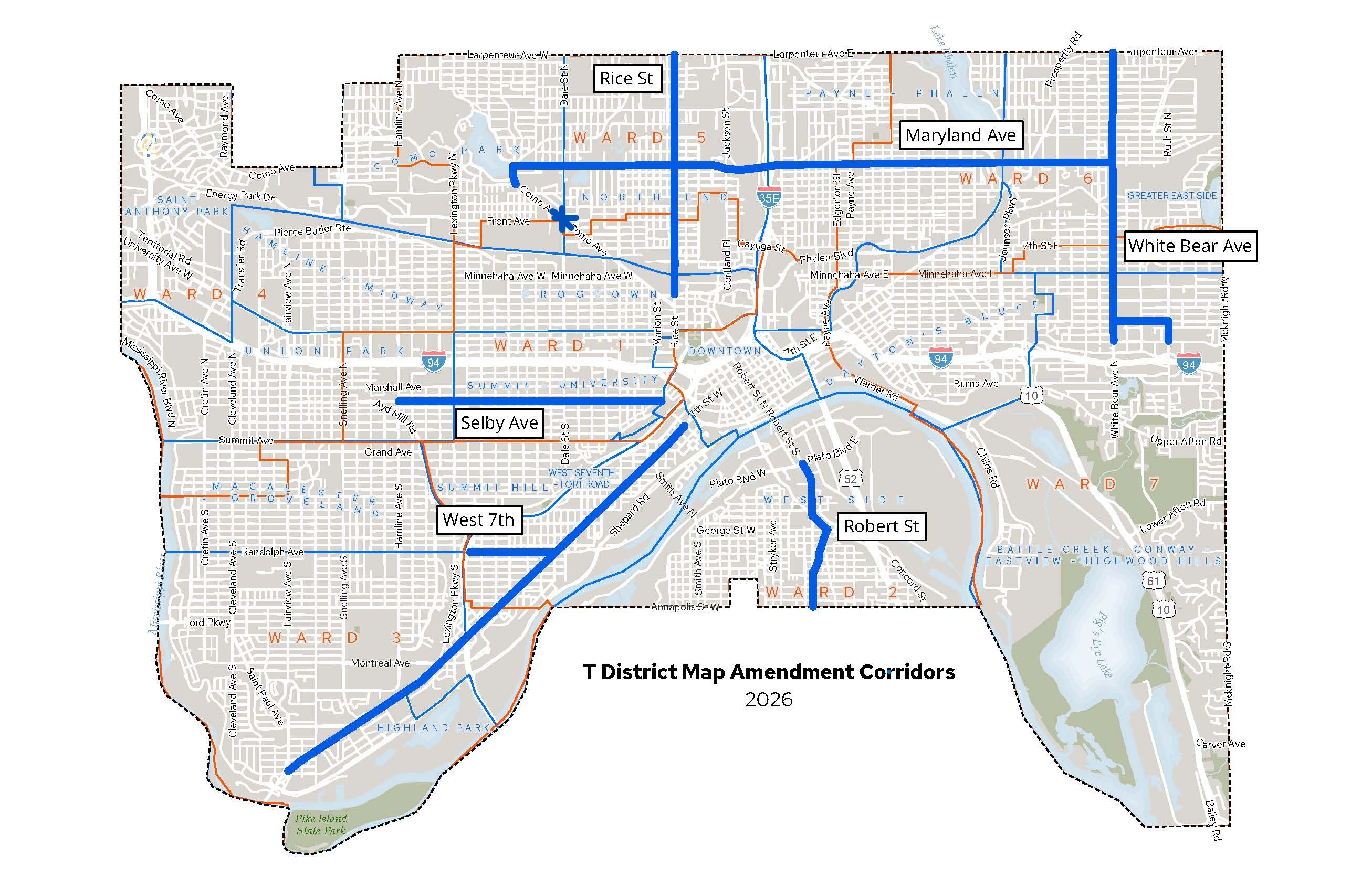
A map of the City of Saint Paul with study corridors highlighted. The corridors include Selby Avenue, West 7th Street, Rice Street, Maryland Avenue, White Bear Avenue, and Robert Street.

The future transit lines encompassed by the project corridors include the H Line (Maryland Ave and White Bear Ave), G Line (Rice St and Robert St), Bronze Line (White Bear Ave), and the proposed J Line (on West 7th.). The Selby Ave portion of the B Line is also included in this study despite the B Line having already entered service. Timing for the Selby Ave corridor was coordinated to allow for the Rondo Small Area Plan to be completed.

The corridors pictured are general study areas; not every parcel along every corridor will be rezoned and some locations incidental to a corridor are not shown on the map. 

Community Engagement  

Community engagement will take place throughout the rest of 2026. You can contribute by: 

  • Leaving comments on our interactive map and/or taking a corridor survey through Engage Saint Paul - coming soon
  • If you live, work, own a business, or otherwise spend time on one of the corridors, consider attending one of our in-person workshops along each corridor.
    • Scheduled workshops are shown in the timeline below. 

Timeline  

The table below shows a general timeline and links to relevant information. Specific dates will be added as they are confirmed and are subject to change.  

StatusDateBody/ActivityAction
Complete ✅November 12, 2025City Council

Initiate zoning study.

In ProgressAll 2026Staff develops draft map amendments 
Complete ✅July 28, 2026 

White Bear Avenue Community Workshop

5:30-7:30pm, Hazel Park Rec Center 

945 Hazel St N, Saint Paul, MN 55119

 September 23, 2026

Selby Avenue Community Workshop 

6:00-7:30pm, Martin Luther King Jr. Rec Center 

271 N Mackubin St, Saint Paul, MN 55102

Discuss recommendations for proposed rezonings along Selby Avenue. 
 September 29, 2026

Maryland Avenue Community Workshop 

6:00-7:30pm, Arlington Hills Library (start time changed from 5:30)

1200 Payne Ave, Saint Paul, MN 55130 

Discuss recommendations for proposed rezonings along Maryland Avenue and at the intersection of Como Ave, Front Ave, and Dale St. 
 October 5, 2026

West 7th Street Community Workshop 

6:00-7:30pm, Palace Rec Center 

781 Palace Ave, Saint Paul, MN 55102

Discuss recommendations for proposed rezonings along West 7th Street and Randolph Avenue. 
 October 22, 2026

Rice Street Community Workshop 

6:00-7:30pm, North End Community Center  

145 Lawson Ave W, Saint Paul, MN 55117

Discuss recommendations for proposed rezonings along Rice Street. 
 Fall 2026

Robert St Community Workshop

TBD 

 
 Winter 2026Planning CommissionReview and analyze proposed map amendments.
 Winter 2026Public comment period on proposed map amendments 
 Winter 2026/2027Planning CommissionPublic hearing on proposed map amendments.
 Early 2027 City CouncilAdoption of proposed map amendments.